Linzhai geodata
Linzhai (Guangdong) is a seat of a fourth-order administrative division; located in China in Asia/Shanghai (GMT+8) time zone. In our database, there are 1268 cities with bigger population. Compared to other cities in China, 89.2% of cities are located further ↑North; 54.7% of cities are located further ←West and 62.3% of cities have higher elevation than Linzhai. Note1


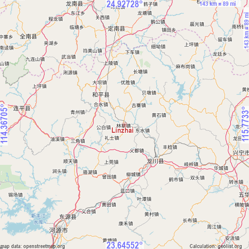
Linzhai GPS coordinates[2]
24° 17' 16.872" North, 115° 4' 12.612" East
| Map corner | latitude | longitude |
|---|---|---|
| Upper-left | 24.92728°, | 114.36705° |
| Center: | 24.28802°, | 115.07017° |
| Lower-right: | 23.64552°, | 115.7733° |
| Map W x H: | 142.5×142.5 km | = 88.5×88.5mi |
| max Lat: | 53.31946° ⇑89.2% North |
| Linzhai: | 24.28802° |
| min Lat: | ⇓10.8% South 18.22056° |
| min Long | Linzhai | max Long |
| 75.07348° | 115.07017° | 134.28917° |
| W 54.7%⇐ | ⇒45.3% E |
Elevation
Elevation of Linzhai is 86 m = 282 ft, and this is 398.8 m = 1308 ft below average elevation for this country.
| Max E: |
5622 m = 18445 ft | 62.3% |
| Avg. | 484.8 m = 1591 ft | |
| Linzhai | 86 m = 282 ft | |
Min E: |
-3 m = -10 ft | 37.7% |
See also: China elevation on elevation.city.
Geographical zone
Linzhai is located in North temperate zone (between Tropic of Cancer and the Arctic Circle). Distance of this Northern Tropic circle is 94.7 km =58.8 mi to South.| Distance of | km | miles | from Linzhai |
|---|---|---|---|
| North Pole | 7306.5 | 4540 | to North |
| Arctic Circle | 4700.6 | 2920.8 | to North |
| Tropic Cancer | 94.7 | 58.8 | to South |
| Equator | 2700.6 | 1678.1 | to South |


Nearby cities:
15 places around Linzhai: (largest is in red/bold)
• Beidun
23.6 km =14.7 mi,  37°
37°
• Chuantang
19.5 km =12.1 mi,  222°
222°
• Dongshui
11 km =6.8 mi,  108°
108°
• Gongbai
11.8 km =7.3 mi,  265°
265°
• Guzhai
13.9 km =8.6 mi,  34°
34°
• Heshui
18.2 km =11.3 mi,  310°
310°
• Huangshi
20.3 km =12.6 mi,  73°
73°
• Lishi
10.4 km =6.5 mi,  225°
225°
• Pengzhai
8.6 km =5.3 mi,  7°
7°
• Shangguan
22.6 km =14 mi,  201°
201°
• Sidu
20 km =12.4 mi, 113°
• Xiuduan
21.9 km =13.6 mi,  264°
264°
• Yangming
22.9 km =14.2 mi,  323°
323°
• Yidu
16 km =9.9 mi,  154°
154°
• Yousheng
24.7 km =15.3 mi,  3°
3°
Sources, notices
• [Note1] Compared only with cities in China existing in our database
• [Src1] Map data: © OpenStreetMap contributors (CC-BY-SA)
• [Src2] Other city data from geonames.org with taken over terms of usage.
• [Src3] Geographical zone / Annual Mean Temperature by Robert A. Rohde @ Wikipedia
