Shen’ao geodata
Shen’ao (Guangdong) is a seat of a fourth-order administrative division; located in China in Asia/Shanghai (GMT+8) time zone. In our database, there are 1268 cities with bigger population. Compared to other cities in China, 92.4% of cities are located further ↑North; 66.5% of cities are located further ←West and 54.6% of cities have lower elevation than Shen’ao. Note1


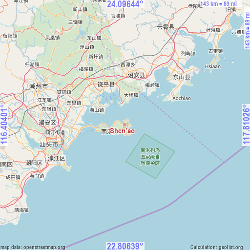
Shen’ao GPS coordinates[2]
23° 27' 10.764" North, 117° 6' 25.668" East
| Map corner | latitude | longitude |
|---|---|---|
| Upper-left | 24.09644°, | 116.40401° |
| Center: | 23.45299°, | 117.10713° |
| Lower-right: | 22.80639°, | 117.81026° |
| Map W x H: | 143.4×143.4 km | = 89.1×89.1mi |
| max Lat: | 53.31946° ⇑92.4% North |
| Shen’ao: | 23.45299° |
| min Lat: | ⇓7.6% South 18.22056° |
| min Long | Shen’ao | max Long |
| 75.07348° | 117.10713° | 134.28917° |
| W 66.5%⇐ | ⇒33.5% E |
Elevation
Elevation of Shen’ao is 203 m = 666 ft, and this is 281.8 m = 925 ft below average elevation for this country.
| Max E: |
5622 m = 18445 ft | 45.4% |
| Avg. | 484.8 m = 1591 ft | |
| Shen’ao | 203 m = 666 ft | |
Min E: |
-3 m = -10 ft | 54.6% |
See also: China elevation on elevation.city.
Geographical zone
Shen’ao is located in North temperate zone (between Tropic of Cancer and the Arctic Circle). Distance of this Northern Tropic circle is 1.8 km =1.1 mi to South.| Distance of | km | miles | from Shen’ao |
|---|---|---|---|
| North Pole | 7399.3 | 4597.7 | to North |
| Arctic Circle | 4793.4 | 2978.5 | to North |
| Tropic Cancer | 1.8 | 1.1 | to South |
| Equator | 2607.7 | 1620.3 | to South |


Nearby cities:
15 places around Shen’ao: (largest is in red/bold)
• Chencheng
32.2 km =20 mi,  60°
60°
• Dacheng
18.5 km =11.5 mi,  17°
17°
• Haishan
17.8 km =11.1 mi,  298°
298°
• Houzhai
9.3 km =5.8 mi,  250°
250°
• Huanggang
27.2 km =16.9 mi,  336°
336°
• Jingzhou
26.8 km =16.7 mi,  318°
318°
• Lincuo
27.8 km =17.3 mi,  33°
33°
• Nanzhao
30.4 km =18.9 mi,  12°
12°
• Shenqiao
31 km =19.3 mi, 6°
• Suocheng
17.5 km =10.9 mi,  2°
2°
• Xingxi
29.3 km =18.2 mi, 16°
• Xinzhai
30 km =18.6 mi, 8°
• Yanhong
30 km =18.6 mi, 302°
• Yun’ao
4.9 km =3 mi,  166°
166°
• Zhelin
14.2 km =8.8 mi,  358°
358°
Sources, notices
• [Note1] Compared only with cities in China existing in our database
• [Src1] Map data: © OpenStreetMap contributors (CC-BY-SA)
• [Src2] Other city data from geonames.org with taken over terms of usage.
• [Src3] Geographical zone / Annual Mean Temperature by Robert A. Rohde @ Wikipedia
