Donglin geodata
Donglin (Fujian) is a seat of a fourth-order administrative division; located in China in Asia/Shanghai (GMT+8) time zone. In our database, there are 1268 cities with bigger population. Compared to other cities in China, 90.9% of cities are located further ↑North; 69.2% of cities are located further ←West and 88.7% of cities have higher elevation than Donglin. Note1


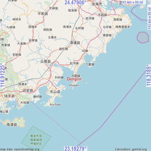
Donglin GPS coordinates[2]
23° 50' 15.072" North, 117° 36' 55.332" East
| Map corner | latitude | longitude |
|---|---|---|
| Upper-left | 24.47906°, | 116.91225° |
| Center: | 23.83752°, | 117.61537° |
| Lower-right: | 23.19279°, | 118.3185° |
| Map W x H: | 143×143 km | = 88.9×88.9mi |
| max Lat: | 53.31946° ⇑90.9% North |
| Donglin: | 23.83752° |
| min Lat: | ⇓9.1% South 18.22056° |
| min Long | Donglin | max Long |
| 75.07348° | 117.61537° | 134.28917° |
| W 69.2%⇐ | ⇒30.8% E |
Elevation
Elevation of Donglin is 11 m = 36 ft, and this is 473.8 m = 1554 ft below average elevation for this country.
| Max E: |
5622 m = 18445 ft | 88.7% |
| Avg. | 484.8 m = 1591 ft | |
| Donglin | 11 m = 36 ft | |
Min E: |
-3 m = -10 ft | 11.3% |
See also: China elevation on elevation.city.
Geographical zone
Donglin is located in North temperate zone (between Tropic of Cancer and the Arctic Circle). Distance of this Northern Tropic circle is 44.6 km =27.7 mi to South.| Distance of | km | miles | from Donglin |
|---|---|---|---|
| North Pole | 7356.6 | 4571.2 | to North |
| Arctic Circle | 4750.7 | 2951.9 | to North |
| Tropic Cancer | 44.6 | 27.7 | to South |
| Equator | 2650.5 | 1646.9 | to South |


Nearby cities:
15 places around Donglin: (largest is in red/bold)
• Aozhong
17.3 km =10.7 mi,  51°
51°
• Chencheng
35.9 km =22.3 mi,  221°
221°
• Chendai
22.3 km =13.9 mi,  257°
257°
• Dongkeng
26.8 km =16.7 mi,  297°
297°
• Dongyingcun
28.7 km =17.8 mi,  234°
234°
• Kangmei
18.4 km =11.4 mi, 232°
• Lieyu
15.6 km =9.7 mi, 264°
• Lushikeng
37.6 km =23.4 mi, 256°
• Meizhou
30.9 km =19.2 mi, 264°
• Sidu
35.3 km =21.9 mi, 260°
• Sui’an
27.7 km =17.2 mi,  358°
358°
• Xipu
24.7 km =15.3 mi, 231°
• Yunling
31.2 km =19.4 mi,  294°
294°
• Zhangtang
21.5 km =13.4 mi, 233°
• Zhengyang
12 km =7.5 mi,  353°
353°
Sources, notices
• [Note1] Compared only with cities in China existing in our database
• [Src1] Map data: © OpenStreetMap contributors (CC-BY-SA)
• [Src2] Other city data from geonames.org with taken over terms of usage.
• [Src3] Geographical zone / Annual Mean Temperature by Robert A. Rohde @ Wikipedia
