Sui’an geodata
Sui’an (Fujian) is a seat of a third-order administrative division; located in China in Asia/Shanghai (GMT+8) time zone. In our database, there are 1268 cities with bigger population. Compared to other cities in China, 90.1% of cities are located further ↑North; 69.1% of cities are located further ←West and 86.9% of cities have higher elevation than Sui’an. Note1


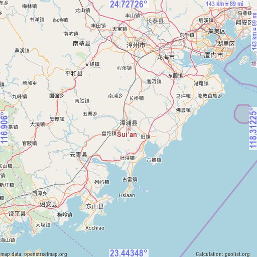
Sui’an GPS coordinates[2]
24° 5' 13.128" North, 117° 36' 32.832" East
| Map corner | latitude | longitude |
|---|---|---|
| Upper-left | 24.72726°, | 116.906° |
| Center: | 24.08698°, | 117.60912° |
| Lower-right: | 23.44348°, | 118.31225° |
| Map W x H: | 142.7×142.7 km | = 88.7×88.7mi |
| max Lat: | 53.31946° ⇑90.1% North |
| Sui’an: | 24.08698° |
| min Lat: | ⇓9.9% South 18.22056° |
| min Long | Sui’an | max Long |
| 75.07348° | 117.60912° | 134.28917° |
| W 69.1%⇐ | ⇒30.9% E |
Elevation
Elevation of Sui’an is 13 m = 43 ft, and this is 471.8 m = 1548 ft below average elevation for this country.
| Max E: |
5622 m = 18445 ft | 86.9% |
| Avg. | 484.8 m = 1591 ft | |
| Sui’an | 13 m = 43 ft | |
Min E: |
-3 m = -10 ft | 13.1% |
See also: China elevation on elevation.city.
Geographical zone
Sui’an is located in North temperate zone (between Tropic of Cancer and the Arctic Circle). Distance of this Northern Tropic circle is 72.3 km =44.9 mi to South.| Distance of | km | miles | from Sui’an |
|---|---|---|---|
| North Pole | 7328.8 | 4553.9 | to North |
| Arctic Circle | 4723 | 2934.7 | to North |
| Tropic Cancer | 72.3 | 44.9 | to South |
| Equator | 2678.2 | 1664.2 | to South |


Nearby cities:
15 places around Sui’an: (largest is in red/bold)
• Aozhong
22 km =13.7 mi,  140°
140°
• Chendai
38.8 km =24.1 mi,  213°
213°
• Dongkeng
27.6 km =17.1 mi,  236°
236°
• Donglin
27.7 km =17.2 mi,  178°
178°
• Kangmei
41.5 km =25.8 mi,  199°
199°
• Lieyu
32.8 km =20.4 mi, 207°
• Meizhou
43.2 km =26.8 mi,  224°
224°
• Nanpu
19.7 km =12.2 mi,  341°
341°
• Shima
45 km =28 mi,  27°
27°
• Xiahe
35 km =21.7 mi,  256°
256°
• Xiaoxi
43.7 km =27.2 mi,  312°
312°
• Yunling
31.4 km =19.5 mi, 241°
• Zhaizipu
38 km =23.6 mi,  247°
247°
• Zhangtang
43.9 km =27.3 mi, 202°
• Zhengyang
15.8 km =9.8 mi, 182°
Sources, notices
• [Note1] Compared only with cities in China existing in our database
• [Src1] Map data: © OpenStreetMap contributors (CC-BY-SA)
• [Src2] Other city data from geonames.org with taken over terms of usage.
• [Src3] Geographical zone / Annual Mean Temperature by Robert A. Rohde @ Wikipedia
