Luozhen geodata
Luozhen (Jiangxi) is a seat of a fourth-order administrative division; located in China in Asia/Shanghai (GMT+8) time zone. In our database, there are 1268 cities with bigger population. Compared to other cities in China, 73.1% of cities are located further ↑North; 61.5% of cities are located further ←West and 76.7% of cities have higher elevation than Luozhen. Note1


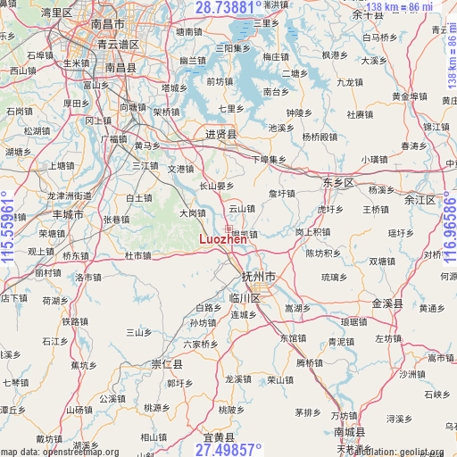
Luozhen GPS coordinates[2]
28° 7' 13.728" North, 116° 15' 45.828" East
| Map corner | latitude | longitude |
|---|---|---|
| Upper-left | 28.73881°, | 115.55961° |
| Center: | 28.12048°, | 116.26273° |
| Lower-right: | 27.49857°, | 116.96586° |
| Map W x H: | 137.9×137.9 km | = 85.7×85.7mi |
| max Lat: | 53.31946° ⇑73.1% North |
| Luozhen: | 28.12048° |
| min Lat: | ⇓26.9% South 18.22056° |
| min Long | Luozhen | max Long |
| 75.07348° | 116.26273° | 134.28917° |
| W 61.5%⇐ | ⇒38.5% E |
Elevation
Elevation of Luozhen is 33 m = 108 ft, and this is 451.8 m = 1482 ft below average elevation for this country.
| Max E: |
5622 m = 18445 ft | 76.7% |
| Avg. | 484.8 m = 1591 ft | |
| Luozhen | 33 m = 108 ft | |
Min E: |
-3 m = -10 ft | 23.3% |
See also: China elevation on elevation.city.
Geographical zone
Luozhen is located in North temperate zone (between Tropic of Cancer and the Arctic Circle). Distance of this Northern Tropic circle is 520.8 km =323.6 mi to South.| Distance of | km | miles | from Luozhen |
|---|---|---|---|
| North Pole | 6880.4 | 4275.3 | to North |
| Arctic Circle | 4274.5 | 2656.1 | to North |
| Tropic Cancer | 520.8 | 323.6 | to South |
| Equator | 3126.7 | 1942.8 | to South |


Nearby cities:
15 places around Luozhen: (largest is in red/bold)
• Baixu
15.7 km =9.8 mi,  356°
356°
• Changshanyan
14 km =8.7 mi,  343°
343°
• Dagang
9.6 km =6 mi,  293°
293°
• Fubei
13 km =8.1 mi,  166°
166°
• Jinggonglu
16.5 km =10.3 mi,  146°
146°
• Liduzhen
15.5 km =9.6 mi,  317°
317°
• Maxu
20.1 km =12.5 mi,  85°
85°
• Qiaodong
16.6 km =10.3 mi,  144°
144°
• Qingyun
17.6 km =10.9 mi, 148°
• Tongyuan
6.2 km =3.9 mi,  220°
220°
• Wenquan
17.4 km =10.8 mi,  182°
182°
• Xidajie
16.4 km =10.2 mi, 147°
• Yunshan
7.1 km =4.4 mi,  30°
30°
• Zhanping
10.3 km =6.4 mi,  192°
192°
• Zhanxu
19.3 km =12 mi,  54°
54°
Sources, notices
• [Note1] Compared only with cities in China existing in our database
• [Src1] Map data: © OpenStreetMap contributors (CC-BY-SA)
• [Src2] Other city data from geonames.org with taken over terms of usage.
• [Src3] Geographical zone / Annual Mean Temperature by Robert A. Rohde @ Wikipedia
