Ma’an geodata
Ma’an (Jiangxi) is a seat of a fourth-order administrative division; located in China in Asia/Shanghai (GMT+8) time zone. In our database, there are 1268 cities with bigger population. Compared to other cities in China, 75.5% of cities are located further ↑North; 59.5% of cities are located further ←West and 61.5% of cities have higher elevation than Ma’an. Note1


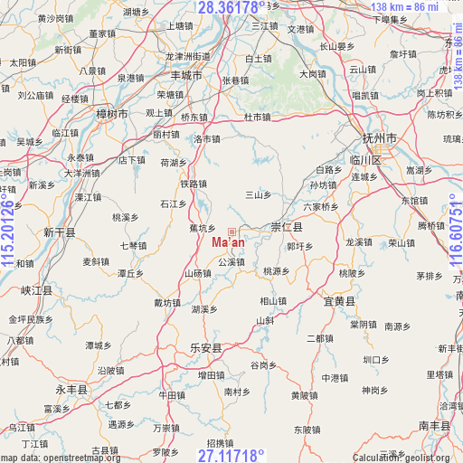
Ma’an GPS coordinates[2]
27° 44' 28.536" North, 115° 54' 15.768" East
| Map corner | latitude | longitude |
|---|---|---|
| Upper-left | 28.36178°, | 115.20126° |
| Center: | 27.74126°, | 115.90438° |
| Lower-right: | 27.11718°, | 116.60751° |
| Map W x H: | 138.4×138.4 km | = 86×86mi |
| max Lat: | 53.31946° ⇑75.5% North |
| Ma’an: | 27.74126° |
| min Lat: | ⇓24.5% South 18.22056° |
| min Long | Ma’an | max Long |
| 75.07348° | 115.90438° | 134.28917° |
| W 59.5%⇐ | ⇒40.5% E |
Elevation
Elevation of Ma’an is 90 m = 295 ft, and this is 394.8 m = 1295 ft below average elevation for this country.
| Max E: |
5622 m = 18445 ft | 61.5% |
| Avg. | 484.8 m = 1591 ft | |
| Ma’an | 90 m = 295 ft | |
Min E: |
-3 m = -10 ft | 38.5% |
See also: China elevation on elevation.city.
Geographical zone
Ma’an is located in North temperate zone (between Tropic of Cancer and the Arctic Circle). Distance of this Northern Tropic circle is 478.6 km =297.4 mi to South.| Distance of | km | miles | from Ma’an |
|---|---|---|---|
| North Pole | 6922.5 | 4301.4 | to North |
| Arctic Circle | 4316.6 | 2682.2 | to North |
| Tropic Cancer | 478.6 | 297.4 | to South |
| Equator | 3084.5 | 1916.6 | to South |


Nearby cities:
15 places around Ma’an: (largest is in red/bold)
• Baibei
7 km =4.3 mi,  2°
2°
• Bashan
14.7 km =9.1 mi,  78°
78°
• Gongfang
22.3 km =13.9 mi,  221°
221°
• Gongxi
8.9 km =5.5 mi,  180°
180°
• Guoxu
20.8 km =12.9 mi,  101°
101°
• Heshang
17.8 km =11.1 mi,  38°
38°
• Jiaokeng
8.8 km =5.5 mi,  280°
280°
• Libei
24.9 km =15.5 mi,  115°
115°
• Sanshan
13.9 km =8.6 mi, 36°
• Shandang
16.1 km =10 mi, 220°
• Shijiang
19.9 km =12.4 mi,  296°
296°
• Taoyuan
17.7 km =11 mi,  130°
130°
• Tielu
18.5 km =11.5 mi,  321°
321°
• Xiangshan
23.9 km =14.9 mi,  148°
148°
• Zhangfang
15.3 km =9.5 mi, 151°
Sources, notices
• [Note1] Compared only with cities in China existing in our database
• [Src1] Map data: © OpenStreetMap contributors (CC-BY-SA)
• [Src2] Other city data from geonames.org with taken over terms of usage.
• [Src3] Geographical zone / Annual Mean Temperature by Robert A. Rohde @ Wikipedia
