Baibei geodata
Baibei (Jiangxi) is a seat of a fourth-order administrative division; located in China in Asia/Shanghai (GMT+8) time zone. In our database, there are 1268 cities with bigger population. Compared to other cities in China, 75.2% of cities are located further ↑North; 59.5% of cities are located further ←West and 61.3% of cities have higher elevation than Baibei. Note1


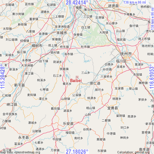
Baibei GPS coordinates[2]
27° 48' 14.328" North, 115° 54' 26.64" East
| Map corner | latitude | longitude |
|---|---|---|
| Upper-left | 28.42414°, | 115.20428° |
| Center: | 27.80398°, | 115.9074° |
| Lower-right: | 27.18026°, | 116.61053° |
| Map W x H: | 138.3×138.3 km | = 85.9×85.9mi |
| max Lat: | 53.31946° ⇑75.2% North |
| Baibei: | 27.80398° |
| min Lat: | ⇓24.8% South 18.22056° |
| min Long | Baibei | max Long |
| 75.07348° | 115.9074° | 134.28917° |
| W 59.5%⇐ | ⇒40.5% E |
Elevation
Elevation of Baibei is 91 m = 299 ft, and this is 393.8 m = 1292 ft below average elevation for this country.
| Max E: |
5622 m = 18445 ft | 61.3% |
| Avg. | 484.8 m = 1591 ft | |
| Baibei | 91 m = 299 ft | |
Min E: |
-3 m = -10 ft | 38.7% |
See also: China elevation on elevation.city.
Geographical zone
Baibei is located in North temperate zone (between Tropic of Cancer and the Arctic Circle). Distance of this Northern Tropic circle is 485.6 km =301.7 mi to South.| Distance of | km | miles | from Baibei |
|---|---|---|---|
| North Pole | 6915.5 | 4297.1 | to North |
| Arctic Circle | 4309.7 | 2677.9 | to North |
| Tropic Cancer | 485.6 | 301.7 | to South |
| Equator | 3091.5 | 1921 | to South |


Nearby cities:
15 places around Baibei: (largest is in red/bold)
• Bashan
14.6 km =9.1 mi,  105°
105°
• Gongxi
15.9 km =9.9 mi,  181°
181°
• Hehu
22.8 km =14.2 mi,  307°
307°
• Heshang
12.8 km =8 mi,  57°
57°
• Jiaokeng
10.5 km =6.5 mi,  239°
239°
• Luoshi
22.3 km =13.9 mi,  339°
339°
• Ma’an
7 km =4.3 mi, 182°
• Sanshan
9 km =5.6 mi, 61°
• Shandang
22 km =13.7 mi,  209°
209°
• Shijiang
18.1 km =11.2 mi,  276°
276°
• Taoyuan
22.7 km =14.1 mi,  144°
144°
• Tielu
14 km =8.7 mi,  302°
302°
• Xiushi
22 km =13.7 mi,  4°
4°
• Xiwang
22.4 km =13.9 mi, 296°
• Zhangfang
21.5 km =13.4 mi,  161°
161°
Sources, notices
• [Note1] Compared only with cities in China existing in our database
• [Src1] Map data: © OpenStreetMap contributors (CC-BY-SA)
• [Src2] Other city data from geonames.org with taken over terms of usage.
• [Src3] Geographical zone / Annual Mean Temperature by Robert A. Rohde @ Wikipedia
