Nantai geodata
Nantai (Jiangxi) is a seat of a fourth-order administrative division; located in China in Asia/Shanghai (GMT+8) time zone. In our database, there are 1268 cities with bigger population. Compared to other cities in China, 69.8% of cities are located further ↑North; 62.5% of cities are located further ←West and 76.2% of cities have higher elevation than Nantai. Note1


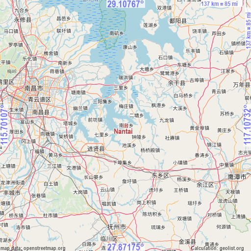
Nantai GPS coordinates[2]
28° 29' 29.472" North, 116° 24' 15.084" East
| Map corner | latitude | longitude |
|---|---|---|
| Upper-left | 29.10767°, | 115.70107° |
| Center: | 28.49152°, | 116.40419° |
| Lower-right: | 27.87175°, | 117.10732° |
| Map W x H: | 137.4×137.4 km | = 85.4×85.4mi |
| max Lat: | 53.31946° ⇑69.8% North |
| Nantai: | 28.49152° |
| min Lat: | ⇓30.2% South 18.22056° |
| min Long | Nantai | max Long |
| 75.07348° | 116.40419° | 134.28917° |
| W 62.5%⇐ | ⇒37.5% E |
Elevation
Elevation of Nantai is 34 m = 112 ft, and this is 450.8 m = 1479 ft below average elevation for this country.
| Max E: |
5622 m = 18445 ft | 76.2% |
| Avg. | 484.8 m = 1591 ft | |
| Nantai | 34 m = 112 ft | |
Min E: |
-3 m = -10 ft | 23.8% |
See also: China elevation on elevation.city.
Geographical zone
Nantai is located in North temperate zone (between Tropic of Cancer and the Arctic Circle). Distance of this Northern Tropic circle is 562 km =349.2 mi to South.| Distance of | km | miles | from Nantai |
|---|---|---|---|
| North Pole | 6839.1 | 4249.6 | to North |
| Arctic Circle | 4233.2 | 2630.4 | to North |
| Tropic Cancer | 562 | 349.2 | to South |
| Equator | 3168 | 1968.5 | to South |


Nearby cities:
15 places around Nantai: (largest is in red/bold)
• Chixi
10.6 km =6.6 mi,  171°
171°
• Dengdun
19.7 km =12.2 mi,  121°
121°
• Fenggang
21.2 km =13.2 mi,  57°
57°
• Heshan
18.7 km =11.6 mi,  50°
50°
• Jiangbu
23.1 km =14.4 mi, 47°
• Jiulong
22.6 km =14 mi,  81°
81°
• Meizhuang
10.8 km =6.7 mi,  1°
1°
• Qianfang
17 km =10.6 mi,  282°
282°
• Qili
14.1 km =8.8 mi,  249°
249°
• Sanli
21.2 km =13.2 mi,  353°
353°
• Xiabuji
20.5 km =12.7 mi,  186°
186°
• Yangqiaodian
18.9 km =11.7 mi,  134°
134°
• Yaqian
22.9 km =14.2 mi, 168°
• Zhaobu
16.4 km =10.2 mi,  302°
302°
• Zhongling
9.3 km =5.8 mi, 129°
Sources, notices
• [Note1] Compared only with cities in China existing in our database
• [Src1] Map data: © OpenStreetMap contributors (CC-BY-SA)
• [Src2] Other city data from geonames.org with taken over terms of usage.
• [Src3] Geographical zone / Annual Mean Temperature by Robert A. Rohde @ Wikipedia
