Dengdun geodata
Dengdun (Jiangxi) is a seat of a fourth-order administrative division; located in China in Asia/Shanghai (GMT+8) time zone. In our database, there are 1268 cities with bigger population. Compared to other cities in China, 70.6% of cities are located further ↑North; 63.5% of cities are located further ←West and 77.7% of cities have higher elevation than Dengdun. Note1


Dengdun GPS coordinates[2]
28° 23' 58.56" North, 116° 34' 34.752" East
| Map corner | latitude | longitude |
|---|---|---|
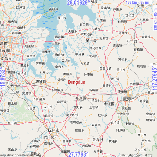
| Upper-left | 29.01629°, | 115.8732° |
| Center: | 28.3996°, | 116.57632° |
| Lower-right: | 27.7793°, | 117.27945° |
| Map W x H: | 137.5×137.5 km | = 85.4×85.4mi |
| max Lat: | 53.31946° ⇑70.6% North |
| Dengdun: | 28.3996° |
| min Lat: | ⇓29.4% South 18.22056° |
| min Long | Dengdun | max Long |
| 75.07348° | 116.57632° | 134.28917° |
| W 63.5%⇐ | ⇒36.5% E |
Elevation
Elevation of Dengdun is 31 m = 102 ft, and this is 453.8 m = 1489 ft below average elevation for this country.
| Max E: |
5622 m = 18445 ft | 77.7% |
| Avg. | 484.8 m = 1591 ft | |
| Dengdun | 31 m = 102 ft | |
Min E: |
-3 m = -10 ft | 22.3% |
See also: China elevation on elevation.city.
Geographical zone
Dengdun is located in North temperate zone (between Tropic of Cancer and the Arctic Circle). Distance of this Northern Tropic circle is 551.8 km =342.9 mi to South.| Distance of | km | miles | from Dengdun |
|---|---|---|---|
| North Pole | 6849.3 | 4256 | to North |
| Arctic Circle | 4243.4 | 2636.7 | to North |
| Tropic Cancer | 551.8 | 342.9 | to South |
| Equator | 3157.7 | 1962.1 | to South |


Nearby cities:
15 places around Dengdun: (largest is in red/bold)
• Chixi
15.3 km =9.5 mi,  268°
268°
• Dengjiaxiang
16.5 km =10.3 mi,  185°
185°
• Fenggang
21.6 km =13.4 mi,  2°
2°
• Heshan
22.2 km =13.8 mi,  353°
353°
• Jiulong
14.6 km =9.1 mi,  22°
22°
• Meigang
23.7 km =14.7 mi,  79°
79°
• Nantai
19.7 km =12.2 mi,  301°
301°
• Pogan
21.8 km =13.5 mi,  111°
111°
• Shegeng
9.4 km =5.8 mi,  64°
64°
• Xiabuji
21.5 km =13.4 mi,  241°
241°
• Xiaohuang
16.3 km =10.1 mi,  126°
126°
• Xushangqiao
19.2 km =11.9 mi, 188°
• Yangqiaodian
4.6 km =2.9 mi,  227°
227°
• Yaqian
17.2 km =10.7 mi,  224°
224°
• Zhongling
10.5 km =6.5 mi,  294°
294°
Sources, notices
• [Note1] Compared only with cities in China existing in our database
• [Src1] Map data: © OpenStreetMap contributors (CC-BY-SA)
• [Src2] Other city data from geonames.org with taken over terms of usage.
• [Src3] Geographical zone / Annual Mean Temperature by Robert A. Rohde @ Wikipedia
