Xufang geodata
Xufang (Jiangxi) is a seat of a fourth-order administrative division; located in China in Asia/Shanghai (GMT+8) time zone. In our database, there are 1268 cities with bigger population. Compared to other cities in China, 76% of cities are located further ↑North; 61.3% of cities are located further ←West and 63.9% of cities have higher elevation than Xufang. Note1


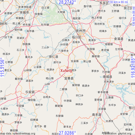
Xufang GPS coordinates[2]
27° 39' 11.412" North, 116° 13' 7.392" East
| Map corner | latitude | longitude |
|---|---|---|
| Upper-left | 28.2742°, | 115.5156° |
| Center: | 27.65317°, | 116.21872° |
| Lower-right: | 27.0286°, | 116.92185° |
| Map W x H: | 138.5×138.5 km | = 86.1×86.1mi |
| max Lat: | 53.31946° ⇑76% North |
| Xufang: | 27.65317° |
| min Lat: | ⇓24% South 18.22056° |
| min Long | Xufang | max Long |
| 75.07348° | 116.21872° | 134.28917° |
| W 61.3%⇐ | ⇒38.7% E |
Elevation
Elevation of Xufang is 78 m = 256 ft, and this is 406.8 m = 1335 ft below average elevation for this country.
| Max E: |
5622 m = 18445 ft | 63.9% |
| Avg. | 484.8 m = 1591 ft | |
| Xufang | 78 m = 256 ft | |
Min E: |
-3 m = -10 ft | 36.1% |
See also: China elevation on elevation.city.
Geographical zone
Xufang is located in North temperate zone (between Tropic of Cancer and the Arctic Circle). Distance of this Northern Tropic circle is 468.8 km =291.3 mi to South.| Distance of | km | miles | from Xufang |
|---|---|---|---|
| North Pole | 6932.3 | 4307.5 | to North |
| Arctic Circle | 4326.4 | 2688.3 | to North |
| Tropic Cancer | 468.8 | 291.3 | to South |
| Equator | 3074.7 | 1910.5 | to South |


Nearby cities:
15 places around Xufang: (largest is in red/bold)
• Bashan
21 km =13 mi,  307°
307°
• Erdu
22.4 km =13.9 mi,  191°
191°
• Fenggang
12 km =7.5 mi,  181°
181°
• Guoxu
12 km =7.5 mi,  298°
298°
• Hangbu
18.2 km =11.3 mi,  8°
8°
• Hebu
23.2 km =14.4 mi,  49°
49°
• Libei
8.5 km =5.3 mi,  264°
264°
• Liujiaqiao
17.8 km =11.1 mi,  345°
345°
• Lixi
14.8 km =9.2 mi,  100°
100°
• Longxi
9.6 km =6 mi, 45°
• Qiuxi
22.4 km =13.9 mi, 13°
• Tangyin
19.6 km =12.2 mi,  154°
154°
• Taobei
5.6 km =3.5 mi,  114°
114°
• Taoyuan
17.6 km =10.9 mi, 264°
• Xiangshan
21.4 km =13.3 mi,  240°
240°
Sources, notices
• [Note1] Compared only with cities in China existing in our database
• [Src1] Map data: © OpenStreetMap contributors (CC-BY-SA)
• [Src2] Other city data from geonames.org with taken over terms of usage.
• [Src3] Geographical zone / Annual Mean Temperature by Robert A. Rohde @ Wikipedia
