Xincheng geodata
Xincheng (Hunan) is a seat of a fourth-order administrative division; located in China in Asia/Shanghai (GMT+8) time zone. In our database, there are 1268 cities with bigger population. Compared to other cities in China, 60.2% of cities are located further ↑North; 74.1% of cities are located further →East and 72.3% of cities have lower elevation than Xincheng. Note1


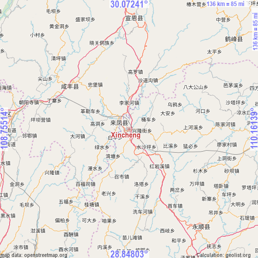
Xincheng GPS coordinates[2]
29° 27' 43.452" North, 109° 27' 29.736" East
| Map corner | latitude | longitude |
|---|---|---|
| Upper-left | 30.07241°, | 108.75514° |
| Center: | 29.46207°, | 109.45826° |
| Lower-right: | 28.84803°, | 110.16139° |
| Map W x H: | 136.1×136.1 km | = 84.6×84.6mi |
| max Lat: | 53.31946° ⇑60.2% North |
| Xincheng: | 29.46207° |
| min Lat: | ⇓39.8% South 18.22056° |
| min Long | Xincheng | max Long |
| 75.07348° | 109.45826° | 134.28917° |
| W 25.9%⇐ | ⇒74.1% E |
Elevation
Elevation of Xincheng is 460 m = 1509 ft, and this is 24.8 m = 81 ft below average elevation for this country.
| Max E: |
5622 m = 18445 ft | 27.7% |
| Avg. | 484.8 m = 1591 ft | |
| Xincheng | 460 m = 1509 ft | |
Min E: |
-3 m = -10 ft | 72.3% |
See also: China elevation on elevation.city.
Geographical zone
Xincheng is located in North temperate zone (between Tropic of Cancer and the Arctic Circle). Distance of this Northern Tropic circle is 670 km =416.3 mi to South.| Distance of | km | miles | from Xincheng |
|---|---|---|---|
| North Pole | 6731.2 | 4182.6 | to North |
| Arctic Circle | 4125.3 | 2563.3 | to North |
| Tropic Cancer | 670 | 416.3 | to South |
| Equator | 3275.9 | 2035.5 | to South |


Nearby cities:
15 places around Xincheng: (largest is in red/bold)
• Cengjiawan
9.3 km =5.8 mi,  240°
240°
• Ciyantang
14.3 km =8.9 mi,  111°
111°
• Hujiagou
18 km =11.2 mi,  313°
313°
• Lijiahe
14.1 km =8.8 mi,  359°
359°
• Longzui
16.7 km =10.4 mi,  211°
211°
• Maoping
13.7 km =8.5 mi,  166°
166°
• Min’an
2.1 km =1.3 mi,  262°
262°
• Shangzhai
17.8 km =11.1 mi, 239°
• Shigaoshan
5.8 km =3.6 mi,  6°
6°
• Shipaidong
17.5 km =10.9 mi,  45°
45°
• Shuishaping
13.3 km =8.3 mi,  134°
134°
• Tongche
11.6 km =7.2 mi,  65°
65°
• Xiangfeng
7.4 km =4.6 mi, 313°
• Xiluo
6 km =3.7 mi, 172°
• Xinglongjie
7 km =4.3 mi,  96°
96°
Sources, notices
• [Note1] Compared only with cities in China existing in our database
• [Src1] Map data: © OpenStreetMap contributors (CC-BY-SA)
• [Src2] Other city data from geonames.org with taken over terms of usage.
• [Src3] Geographical zone / Annual Mean Temperature by Robert A. Rohde @ Wikipedia
