Cengjiawan geodata
Cengjiawan (Hunan) is a seat of a fourth-order administrative division; located in China in Asia/Shanghai (GMT+8) time zone. In our database, there are 1268 cities with bigger population. Compared to other cities in China, 60.6% of cities are located further ↑North; 74.6% of cities are located further →East and 73.5% of cities have lower elevation than Cengjiawan. Note1


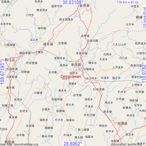
Cengjiawan GPS coordinates[2]
29° 25' 13.764" North, 109° 22' 30.252" East
| Map corner | latitude | longitude |
|---|---|---|
| Upper-left | 30.03108°, | 108.67195° |
| Center: | 29.42049°, | 109.37507° |
| Lower-right: | 28.8062°, | 110.0782° |
| Map W x H: | 136.2×136.2 km | = 84.6×84.6mi |
| max Lat: | 53.31946° ⇑60.6% North |
| Cengjiawan: | 29.42049° |
| min Lat: | ⇓39.4% South 18.22056° |
| min Long | Cengjiawan | max Long |
| 75.07348° | 109.37507° | 134.28917° |
| W 25.4%⇐ | ⇒74.6% E |
Elevation
Elevation of Cengjiawan is 486 m = 1594 ft, and this is 1.2 m = 4 ft above average elevation for this country.
| Max E: |
5622 m = 18445 ft | 26.5% |
| Cengjiawan | 486 m 1594 ft | |
| Avg. | 484.8 m = 1591 ft | |
Min E: |
-3 m = -10 ft | 73.5% |
See also: China elevation on elevation.city.
Geographical zone
Cengjiawan is located in North temperate zone (between Tropic of Cancer and the Arctic Circle). Distance of this Northern Tropic circle is 665.3 km =413.4 mi to South.| Distance of | km | miles | from Cengjiawan |
|---|---|---|---|
| North Pole | 6735.8 | 4185.4 | to North |
| Arctic Circle | 4129.9 | 2566.2 | to North |
| Tropic Cancer | 665.3 | 413.4 | to South |
| Equator | 3271.3 | 2032.7 | to South |


Nearby cities:
15 places around Cengjiawan: (largest is in red/bold)
• Chenzhouzhai
18.4 km =11.4 mi,  152°
152°
• Hujiagou
17.8 km =11.1 mi,  343°
343°
• Jiusi
11.7 km =7.3 mi,  277°
277°
• Liangshuijing
17.5 km =10.9 mi,  213°
213°
• Longzui
9.6 km =6 mi,  184°
184°
• Maoping
14.2 km =8.8 mi,  128°
128°
• Min’an
7.4 km =4.6 mi,  54°
54°
• Shangzhai
8.5 km =5.3 mi,  237°
237°
• Shigaoshan
13.5 km =8.4 mi,  40°
40°
• Shuishaping
18.1 km =11.2 mi,  105°
105°
• Xiangfeng
10 km =6.2 mi,  15°
15°
• Xiluo
8.9 km =5.5 mi,  98°
98°
• Xincheng
9.3 km =5.8 mi,  60°
60°
• Xinglongjie
15.5 km =9.6 mi,  75°
75°
• Xinzhaipo
15.8 km =9.8 mi,  163°
163°
Sources, notices
• [Note1] Compared only with cities in China existing in our database
• [Src1] Map data: © OpenStreetMap contributors (CC-BY-SA)
• [Src2] Other city data from geonames.org with taken over terms of usage.
• [Src3] Geographical zone / Annual Mean Temperature by Robert A. Rohde @ Wikipedia
