Qingshui geodata
Qingshui (Hunan) is a seat of a fourth-order administrative division; located in China in Asia/Shanghai (GMT+8) time zone. In our database, there are 1268 cities with bigger population. Compared to other cities in China, 68.9% of cities are located further ↑North; 74% of cities are located further →East and 60.1% of cities have lower elevation than Qingshui. Note1


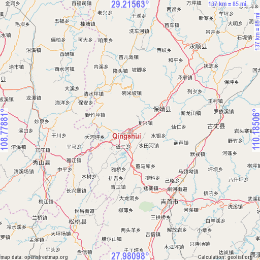
Qingshui GPS coordinates[2]
28° 36' 0.432" North, 109° 28' 54.948" East
| Map corner | latitude | longitude |
|---|---|---|
| Upper-left | 29.21563°, | 108.77881° |
| Center: | 28.60012°, | 109.48193° |
| Lower-right: | 27.98098°, | 110.18506° |
| Map W x H: | 137.3×137.3 km | = 85.3×85.3mi |
| max Lat: | 53.31946° ⇑68.9% North |
| Qingshui: | 28.60012° |
| min Lat: | ⇓31.1% South 18.22056° |
| min Long | Qingshui | max Long |
| 75.07348° | 109.48193° | 134.28917° |
| W 26%⇐ | ⇒74% E |
Elevation
Elevation of Qingshui is 260 m = 853 ft, and this is 224.8 m = 738 ft below average elevation for this country.
| Max E: |
5622 m = 18445 ft | 39.9% |
| Avg. | 484.8 m = 1591 ft | |
| Qingshui | 260 m = 853 ft | |
Min E: |
-3 m = -10 ft | 60.1% |
See also: China elevation on elevation.city.
Geographical zone
Qingshui is located in North temperate zone (between Tropic of Cancer and the Arctic Circle). Distance of this Northern Tropic circle is 574.1 km =356.7 mi to South.| Distance of | km | miles | from Qingshui |
|---|---|---|---|
| North Pole | 6827 | 4242.1 | to North |
| Arctic Circle | 4221.1 | 2622.9 | to North |
| Tropic Cancer | 574.1 | 356.7 | to South |
| Equator | 3180 | 1976 | to South |


Nearby cities:
15 places around Qingshui: (largest is in red/bold)
• Bamao
18.5 km =11.5 mi,  2°
2°
• Boji
8 km =5 mi,  281°
281°
• Dao’er
10.3 km =6.4 mi,  203°
203°
• Datuo
8.6 km =5.3 mi,  350°
350°
• Erong
19.2 km =11.9 mi,  260°
260°
• Fuxing
9 km =5.6 mi,  62°
62°
• Huayuan
1.5 km =0.9 mi, 204°
• Longtan
15.1 km =9.4 mi,  215°
215°
• Malichang
18.3 km =11.4 mi,  177°
177°
• Maogou
10.5 km =6.5 mi,  270°
270°
• Shuitianhe
12.5 km =7.8 mi,  127°
127°
• Shuiyin
15.3 km =9.5 mi,  99°
99°
• Tuanjie
11.7 km =7.3 mi,  240°
240°
• Woshao
10.7 km =6.6 mi, 180°
• Yezhuping
20.2 km =12.6 mi,  294°
294°
Sources, notices
• [Note1] Compared only with cities in China existing in our database
• [Src1] Map data: © OpenStreetMap contributors (CC-BY-SA)
• [Src2] Other city data from geonames.org with taken over terms of usage.
• [Src3] Geographical zone / Annual Mean Temperature by Robert A. Rohde @ Wikipedia
