Daba geodata
Daba (Guangdong) is a seat of a fourth-order administrative division; located in China in Asia/Shanghai (GMT+8) time zone. In our database, there are 1268 cities with bigger population. Compared to other cities in China, 92.8% of cities are located further ↑North; 61.1% of cities are located further ←West and 80.2% of cities have higher elevation than Daba. Note1


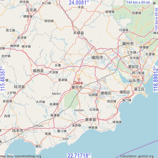
Daba GPS coordinates[2]
23° 21' 51.156" North, 116° 11' 13.164" East
| Map corner | latitude | longitude |
|---|---|---|
| Upper-left | 24.0081°, | 115.48387° |
| Center: | 23.36421°, | 116.18699° |
| Lower-right: | 22.71718°, | 116.89012° |
| Map W x H: | 143.5×143.5 km | = 89.2×89.2mi |
| max Lat: | 53.31946° ⇑92.8% North |
| Daba: | 23.36421° |
| min Lat: | ⇓7.2% South 18.22056° |
| min Long | Daba | max Long |
| 75.07348° | 116.18699° | 134.28917° |
| W 61.1%⇐ | ⇒38.9% E |
Elevation
Elevation of Daba is 26 m = 85 ft, and this is 458.8 m = 1505 ft below average elevation for this country.
| Max E: |
5622 m = 18445 ft | 80.2% |
| Avg. | 484.8 m = 1591 ft | |
| Daba | 26 m = 85 ft | |
Min E: |
-3 m = -10 ft | 19.8% |
See also: China elevation on elevation.city.
Geographical zone
Daba is located in North Torrid zone (between Equator and Tropic of Cancer). Distance of this Northern Tropic circle is 8.1 km =5 mi to North.| Distance of | km | miles | from Daba |
|---|---|---|---|
| North Pole | 7409.2 | 4603.9 | to North |
| Arctic Circle | 4803.3 | 2984.6 | to North |
| Tropic Cancer | 8.1 | 5 | to North |
| Equator | 2597.9 | 1614.3 | to South |


Nearby cities:
15 places around Daba: (largest is in red/bold)
• Chigang
8.1 km =5 mi,  346°
346°
• Chiwei
8.9 km =5.5 mi,  215°
215°
• Dananshan
11.8 km =7.3 mi,  185°
185°
• Fengjiang
11.3 km =7 mi,  324°
324°
• Hongyang
7.9 km =4.9 mi,  20°
20°
• Junbu
14 km =8.7 mi,  148°
148°
• Liaoyuan
4.5 km =2.8 mi, 220°
• Lihu
14.9 km =9.3 mi,  268°
268°
• Meitang
10.8 km =6.7 mi,  260°
260°
• Mianhu
9.9 km =6.2 mi,  330°
330°
• Nanjing
11.6 km =7.2 mi,  103°
103°
• Puning
6.2 km =3.9 mi,  197°
197°
• Qilin
11.9 km =7.4 mi,  56°
56°
• Xiajiashan
14.6 km =9.1 mi, 153°
• Zhanlong
11.7 km =7.3 mi,  135°
135°
Sources, notices
• [Note1] Compared only with cities in China existing in our database
• [Src1] Map data: © OpenStreetMap contributors (CC-BY-SA)
• [Src2] Other city data from geonames.org with taken over terms of usage.
• [Src3] Geographical zone / Annual Mean Temperature by Robert A. Rohde @ Wikipedia
