Xiajiashan geodata
Xiajiashan (Guangdong) is a seat of a fourth-order administrative division; located in China in Asia/Shanghai (GMT+8) time zone. In our database, there are 1268 cities with bigger population. Compared to other cities in China, 93.3% of cities are located further ↑North; 61.5% of cities are located further ←West and 83.9% of cities have higher elevation than Xiajiashan. Note1


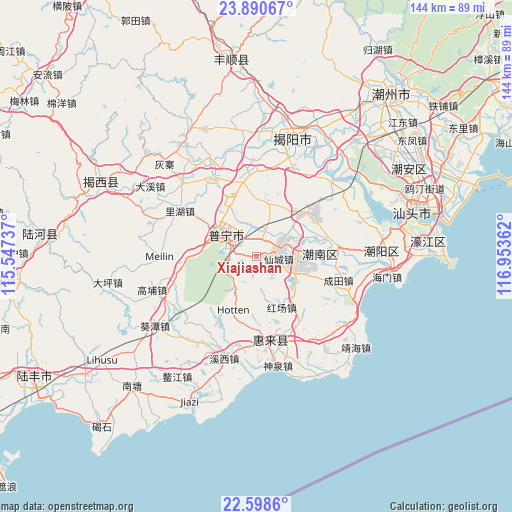
Xiajiashan GPS coordinates[2]
23° 14' 46.32" North, 116° 15' 1.764" East
| Map corner | latitude | longitude |
|---|---|---|
| Upper-left | 23.89067°, | 115.54737° |
| Center: | 23.2462°, | 116.25049° |
| Lower-right: | 22.5986°, | 116.95362° |
| Map W x H: | 143.7×143.7 km | = 89.3×89.3mi |
| max Lat: | 53.31946° ⇑93.3% North |
| Xiajiashan: | 23.2462° |
| min Lat: | ⇓6.7% South 18.22056° |
| min Long | Xiajiashan | max Long |
| 75.07348° | 116.25049° | 134.28917° |
| W 61.5%⇐ | ⇒38.5% E |
Elevation
Elevation of Xiajiashan is 18 m = 59 ft, and this is 466.8 m = 1531 ft below average elevation for this country.
| Max E: |
5622 m = 18445 ft | 83.9% |
| Avg. | 484.8 m = 1591 ft | |
| Xiajiashan | 18 m = 59 ft | |
Min E: |
-3 m = -10 ft | 16.1% |
See also: China elevation on elevation.city.
Geographical zone
Xiajiashan is located in North Torrid zone (between Equator and Tropic of Cancer). Distance of this Northern Tropic circle is 21.2 km =13.2 mi to North.| Distance of | km | miles | from Xiajiashan |
|---|---|---|---|
| North Pole | 7422.3 | 4612 | to North |
| Arctic Circle | 4816.4 | 2992.8 | to North |
| Tropic Cancer | 21.2 | 13.2 | to North |
| Equator | 2584.7 | 1606.1 | to South |


Nearby cities:
15 places around Xiajiashan: (largest is in red/bold)
• Chendian
7.5 km =4.7 mi,  64°
64°
• Chiwei
13 km =8.1 mi,  296°
296°
• Daba
14.6 km =9.1 mi,  333°
333°
• Dananshan
7.8 km =4.8 mi,  280°
280°
• Guiyu
12.7 km =7.9 mi,  48°
48°
• Hongchang
15.4 km =9.6 mi,  156°
156°
• Junbu
1.4 km =0.9 mi,  31°
31°
• Liangying
11.2 km =7 mi,  105°
105°
• Liaoyuan
13.5 km =8.4 mi,  315°
315°
• Nanjing
11.5 km =7.1 mi,  24°
24°
• Puning
11 km =6.8 mi,  310°
310°
• Simapu
11.5 km =7.1 mi,  81°
81°
• Xiancheng
6.9 km =4.3 mi,  98°
98°
• Yunluo
17.9 km =11.1 mi,  269°
269°
• Zhanlong
5.1 km =3.2 mi, 19°
Sources, notices
• [Note1] Compared only with cities in China existing in our database
• [Src1] Map data: © OpenStreetMap contributors (CC-BY-SA)
• [Src2] Other city data from geonames.org with taken over terms of usage.
• [Src3] Geographical zone / Annual Mean Temperature by Robert A. Rohde @ Wikipedia
