Bishagou geodata
Bishagou (Hunan) is a seat of a fourth-order administrative division; located in China in Asia/Shanghai (GMT+8) time zone. In our database, there are 1268 cities with bigger population. Compared to other cities in China, 61.4% of cities are located further ↑North; 73.4% of cities are located further →East and 71.8% of cities have lower elevation than Bishagou. Note1


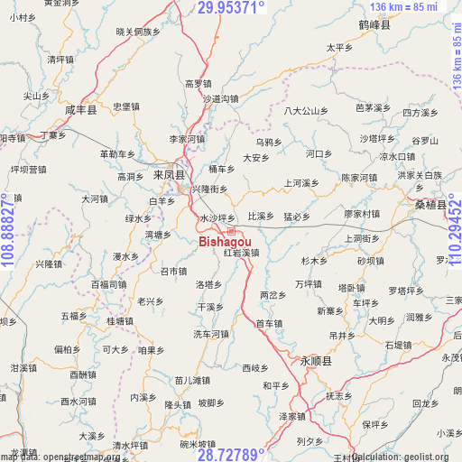
Bishagou GPS coordinates[2]
29° 20' 33.504" North, 109° 35' 29.004" East
| Map corner | latitude | longitude |
|---|---|---|
| Upper-left | 29.95371°, | 108.88827° |
| Center: | 29.34264°, | 109.59139° |
| Lower-right: | 28.72789°, | 110.29452° |
| Map W x H: | 136.3×136.3 km | = 84.7×84.7mi |
| max Lat: | 53.31946° ⇑61.4% North |
| Bishagou: | 29.34264° |
| min Lat: | ⇓38.6% South 18.22056° |
| min Long | Bishagou | max Long |
| 75.07348° | 109.59139° | 134.28917° |
| W 26.6%⇐ | ⇒73.4% E |
Elevation
Elevation of Bishagou is 448 m = 1470 ft, and this is 36.8 m = 121 ft below average elevation for this country.
| Max E: |
5622 m = 18445 ft | 28.2% |
| Avg. | 484.8 m = 1591 ft | |
| Bishagou | 448 m = 1470 ft | |
Min E: |
-3 m = -10 ft | 71.8% |
See also: China elevation on elevation.city.
Geographical zone
Bishagou is located in North temperate zone (between Tropic of Cancer and the Arctic Circle). Distance of this Northern Tropic circle is 656.7 km =408.1 mi to South.| Distance of | km | miles | from Bishagou |
|---|---|---|---|
| North Pole | 6744.5 | 4190.8 | to North |
| Arctic Circle | 4138.6 | 2571.6 | to North |
| Tropic Cancer | 656.7 | 408.1 | to South |
| Equator | 3262.6 | 2027.3 | to South |


Nearby cities:
15 places around Bishagou: (largest is in red/bold)
• Bixidong
10.4 km =6.5 mi,  63°
63°
• Chenzhouzhai
14.6 km =9.1 mi,  238°
238°
• Ciyantang
8 km =5 mi,  2°
2°
• Hongyanxi
7.5 km =4.7 mi,  147°
147°
• Luotache
16.3 km =10.1 mi,  204°
204°
• Maoping
9.8 km =6.1 mi,  269°
269°
• Ruchihe
13 km =8.1 mi,  113°
113°
• Shuishaping
5.3 km =3.3 mi,  317°
317°
• Shuitianba
17.5 km =10.9 mi,  45°
45°
• Tongche
18.3 km =11.4 mi,  352°
352°
• Xiluo
14.2 km =8.8 mi,  301°
301°
• Xinchang
16.4 km =10.2 mi,  124°
124°
• Xincheng
18.5 km =11.5 mi, 315°
• Xinglongjie
13.8 km =8.6 mi,  334°
334°
• Xinzhaipo
17.6 km =10.9 mi,  248°
248°
Sources, notices
• [Note1] Compared only with cities in China existing in our database
• [Src1] Map data: © OpenStreetMap contributors (CC-BY-SA)
• [Src2] Other city data from geonames.org with taken over terms of usage.
• [Src3] Geographical zone / Annual Mean Temperature by Robert A. Rohde @ Wikipedia
