Yipin geodata
Yipin (Chongqing) is a seat of a fourth-order administrative division; located in China in Asia/Shanghai (GMT+8) time zone. In our database, there are 1268 cities with bigger population. Compared to other cities in China, 62.2% of cities are located further ↑North; 84.9% of cities are located further →East and 57.7% of cities have lower elevation than Yipin. Note1


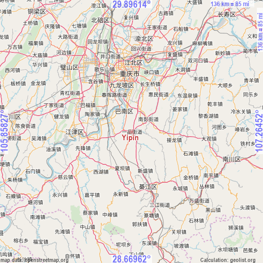
Yipin GPS coordinates[2]
29° 17' 4.992" North, 106° 33' 41.004" East
| Map corner | latitude | longitude |
|---|---|---|
| Upper-left | 29.89614°, | 105.85827° |
| Center: | 29.28472°, | 106.56139° |
| Lower-right: | 28.66962°, | 107.26452° |
| Map W x H: | 136.4×136.4 km | = 84.8×84.8mi |
| max Lat: | 53.31946° ⇑62.2% North |
| Yipin: | 29.28472° |
| min Lat: | ⇓37.8% South 18.22056° |
| min Long | Yipin | max Long |
| 75.07348° | 106.56139° | 134.28917° |
| W 15.1%⇐ | ⇒84.9% E |
Elevation
Elevation of Yipin is 233 m = 764 ft, and this is 251.8 m = 826 ft below average elevation for this country.
| Max E: |
5622 m = 18445 ft | 42.3% |
| Avg. | 484.8 m = 1591 ft | |
| Yipin | 233 m = 764 ft | |
Min E: |
-3 m = -10 ft | 57.7% |
See also: China elevation on elevation.city.
Geographical zone
Yipin is located in North temperate zone (between Tropic of Cancer and the Arctic Circle). Distance of this Northern Tropic circle is 650.2 km =404 mi to South.| Distance of | km | miles | from Yipin |
|---|---|---|---|
| North Pole | 6750.9 | 4194.8 | to North |
| Arctic Circle | 4145 | 2575.6 | to North |
| Tropic Cancer | 650.2 | 404 | to South |
| Equator | 3256.2 | 2023.3 | to South |


Nearby cities:
15 places around Yipin: (largest is in red/bold)
• Dushi
15.2 km =9.4 mi,  190°
190°
• Hengshan
21.9 km =13.6 mi,  150°
150°
• Huimin
24.1 km =15 mi,  35°
35°
• Jiasi
21.8 km =13.5 mi,  210°
210°
• Jielong
21.2 km =13.2 mi,  100°
100°
• Longzhouwan
10.6 km =6.6 mi,  348°
348°
• Luohuang
14 km =8.7 mi,  299°
299°
• Shiban
25.6 km =15.9 mi,  307°
307°
• Taojia
25.3 km =15.7 mi,  292°
292°
• Tiaodeng
18.7 km =11.6 mi,  315°
315°
• Xiaba
19.3 km =12 mi, 194°
• Xinshancun
23.8 km =14.8 mi,  340°
340°
• Xipeng
23.3 km =14.5 mi,  272°
272°
• Yangjiaping
25.2 km =15.7 mi, 346°
• Yudong
11.9 km =7.4 mi, 339°
Sources, notices
• [Note1] Compared only with cities in China existing in our database
• [Src1] Map data: © OpenStreetMap contributors (CC-BY-SA)
• [Src2] Other city data from geonames.org with taken over terms of usage.
• [Src3] Geographical zone / Annual Mean Temperature by Robert A. Rohde @ Wikipedia
