Hengshan geodata
Hengshan (Chongqing) is a seat of a fourth-order administrative division; located in China in Asia/Shanghai (GMT+8) time zone. In our database, there are 1268 cities with bigger population. Compared to other cities in China, 64.2% of cities are located further ↑North; 84.6% of cities are located further →East and 78.1% of cities have lower elevation than Hengshan. Note1


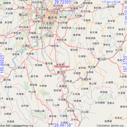
Hengshan GPS coordinates[2]
29° 6' 48.6" North, 106° 40' 20.532" East
| Map corner | latitude | longitude |
|---|---|---|
| Upper-left | 29.72595°, | 105.96925° |
| Center: | 29.1135°, | 106.67237° |
| Lower-right: | 28.49738°, | 107.3755° |
| Map W x H: | 136.6×136.6 km | = 84.9×84.9mi |
| max Lat: | 53.31946° ⇑64.2% North |
| Hengshan: | 29.1135° |
| min Lat: | ⇓35.8% South 18.22056° |
| min Long | Hengshan | max Long |
| 75.07348° | 106.67237° | 134.28917° |
| W 15.4%⇐ | ⇒84.6% E |
Elevation
Elevation of Hengshan is 617 m = 2024 ft, and this is 132.2 m = 434 ft above average elevation for this country.
| Max E: |
5622 m = 18445 ft | 21.9% |
| Hengshan | 617 m 2024 ft | |
| Avg. | 484.8 m = 1591 ft | |
Min E: |
-3 m = -10 ft | 78.1% |
See also: China elevation on elevation.city.
Geographical zone
Hengshan is located in North temperate zone (between Tropic of Cancer and the Arctic Circle). Distance of this Northern Tropic circle is 631.2 km =392.2 mi to South.| Distance of | km | miles | from Hengshan |
|---|---|---|---|
| North Pole | 6769.9 | 4206.6 | to North |
| Arctic Circle | 4164.1 | 2587.5 | to North |
| Tropic Cancer | 631.2 | 392.2 | to South |
| Equator | 3237.1 | 2011.4 | to South |


Nearby cities:
15 places around Hengshan: (largest is in red/bold)
• Dushi
14.1 km =8.8 mi,  286°
286°
• Gunan
10.3 km =6.4 mi,  193°
193°
• Jiasi
21.9 km =13.6 mi,  270°
270°
• Jielong
18.2 km =11.3 mi,  33°
33°
• Jinqiao
21.9 km =13.6 mi,  109°
109°
• Longsheng
14.4 km =8.9 mi,  104°
104°
• Puhechang
23.6 km =14.7 mi,  139°
139°
• Sanjiang
19.1 km =11.9 mi,  168°
168°
• Sanjiao
9.4 km =5.8 mi, 138°
• Shentong
26.1 km =16.2 mi,  73°
73°
• Shijiaochang
22.5 km =14 mi,  158°
158°
• Shitan
21.8 km =13.5 mi, 71°
• Xiaba
15.8 km =9.8 mi, 271°
• Yipin
21.9 km =13.6 mi,  330°
330°
• Yongxin
21.2 km =13.2 mi,  219°
219°
Sources, notices
• [Note1] Compared only with cities in China existing in our database
• [Src1] Map data: © OpenStreetMap contributors (CC-BY-SA)
• [Src2] Other city data from geonames.org with taken over terms of usage.
• [Src3] Geographical zone / Annual Mean Temperature by Robert A. Rohde @ Wikipedia
