Dayang geodata
Dayang (Shaanxi) is a seat of a fourth-order administrative division; located in China in Asia/Shanghai (GMT+8) time zone. In our database, there are 1268 cities with bigger population. Compared to other cities in China, 72.7% of cities are located further ↓South; 79.4% of cities are located further →East and 77.5% of cities have lower elevation than Dayang. Note1


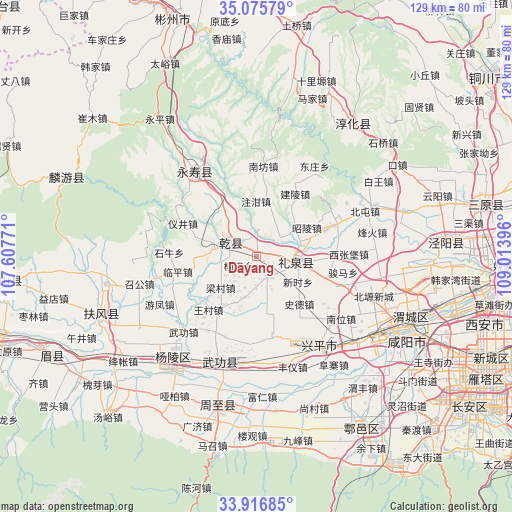
Dayang GPS coordinates[2]
34° 29' 53.988" North, 108° 18' 38.988" East
| Map corner | latitude | longitude |
|---|---|---|
| Upper-left | 35.07579°, | 107.60771° |
| Center: | 34.49833°, | 108.31083° |
| Lower-right: | 33.91685°, | 109.01396° |
| Map W x H: | 128.9×128.9 km | = 80.1×80.1mi |
| max Lat: | 53.31946° ⇑27.3% North |
| Dayang: | 34.49833° |
| min Lat: | ⇓72.7% South 18.22056° |
| min Long | Dayang | max Long |
| 75.07348° | 108.31083° | 134.28917° |
| W 20.6%⇐ | ⇒79.4% E |
Elevation
Elevation of Dayang is 592 m = 1942 ft, and this is 107.2 m = 352 ft above average elevation for this country.
| Max E: |
5622 m = 18445 ft | 22.5% |
| Dayang | 592 m 1942 ft | |
| Avg. | 484.8 m = 1591 ft | |
Min E: |
-3 m = -10 ft | 77.5% |
See also: China elevation on elevation.city.
Geographical zone
Dayang is located in North temperate zone (between Tropic of Cancer and the Arctic Circle). Distance of this Northern Tropic circle is 1229.9 km =764.2 mi to South.| Distance of | km | miles | from Dayang |
|---|---|---|---|
| North Pole | 6171.2 | 3834.6 | to North |
| Arctic Circle | 3565.3 | 2215.4 | to North |
| Tropic Cancer | 1229.9 | 764.2 | to South |
| Equator | 3835.9 | 2383.5 | to South |


Nearby cities:
15 places around Dayang: (largest is in red/bold)
• Daqiang
5.9 km =3.7 mi,  154°
154°
• Jiangcun
12.9 km =8 mi,  204°
204°
• Liangshan
17.4 km =10.8 mi,  321°
321°
• Lingyuan
3.5 km =2.2 mi,  82°
82°
• Liquan Chengguanzhen
10.5 km =6.5 mi,  100°
100°
• Malian
14.6 km =9.1 mi,  171°
171°
• Moxi
11.3 km =7 mi,  279°
279°
• Shide
16 km =9.9 mi,  138°
138°
• Shitan
9.5 km =5.9 mi,  26°
26°
• Wangcun
18 km =11.2 mi,  221°
221°
• Xinyang
15.7 km =9.8 mi,  263°
263°
• Xuelu
10.2 km =6.3 mi,  164°
164°
• Yanghong
2.4 km =1.5 mi,  9°
9°
• Zhaoling
14.4 km =8.9 mi,  60°
60°
• Zhuganzhen
14 km =8.7 mi,  359°
359°
Sources, notices
• [Note1] Compared only with cities in China existing in our database
• [Src1] Map data: © OpenStreetMap contributors (CC-BY-SA)
• [Src2] Other city data from geonames.org with taken over terms of usage.
• [Src3] Geographical zone / Annual Mean Temperature by Robert A. Rohde @ Wikipedia
