Yaotun geodata
Yaotun (Heilongjiang) is a seat of a fourth-order administrative division; located in China in Asia/Shanghai (GMT+8) time zone. In our database, there are 1268 cities with bigger population. Compared to other cities in China, 99.4% of cities are located further ↓South; 97.6% of cities are located further ←West and 55% of cities have lower elevation than Yaotun. Note1


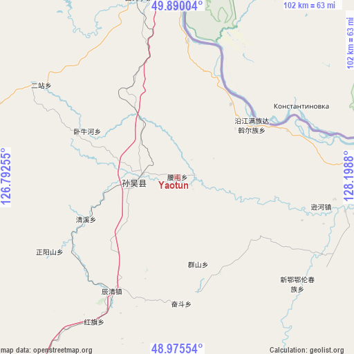
Yaotun GPS coordinates[2]
49° 26' 5.712" North, 127° 29' 44.412" East
| Map corner | latitude | longitude |
|---|---|---|
| Upper-left | 49.89004°, | 126.79255° |
| Center: | 49.43492°, | 127.49567° |
| Lower-right: | 48.97554°, | 128.1988° |
| Map W x H: | 101.7×101.7 km | = 63.2×63.2mi |
| max Lat: | 53.31946° ⇑0.6% North |
| Yaotun: | 49.43492° |
| min Lat: | ⇓99.4% South 18.22056° |
| min Long | Yaotun | max Long |
| 75.07348° | 127.49567° | 134.28917° |
| W 97.6%⇐ | ⇒2.4% E |
Elevation
Elevation of Yaotun is 207 m = 679 ft, and this is 277.8 m = 911 ft below average elevation for this country.
| Max E: |
5622 m = 18445 ft | 45% |
| Avg. | 484.8 m = 1591 ft | |
| Yaotun | 207 m = 679 ft | |
Min E: |
-3 m = -10 ft | 55% |
See also: China elevation on elevation.city.
Geographical zone
Yaotun is located in North temperate zone (between Tropic of Cancer and the Arctic Circle). Distance of this North polar circle is 1904.5 km =1183.4 mi to North.| Distance of | km | miles | from Yaotun |
|---|---|---|---|
| North Pole | 4510.4 | 2802.6 | to North |
| Arctic Circle | 1904.5 | 1183.4 | to North |
| Tropic Cancer | 2890.7 | 1796.2 | to South |
| Equator | 5496.6 | 3415.4 | to South |


Nearby cities:
15 places around Yaotun: (largest is in red/bold)
• Chenqing
37.7 km =23.4 mi,  209°
209°
• Erzhan
47.2 km =29.3 mi,  304°
304°
• Fendou
35.9 km =22.3 mi,  178°
178°
• Hongqi
47.7 km =29.6 mi, 210°
• Kunheda Woerzu Manzu
50 km =31.1 mi,  0°
0°
• Qingxi
28.5 km =17.7 mi,  244°
244°
• Qunshan
24.9 km =15.5 mi,  166°
166°
• Sunwu
13.2 km =8.2 mi,  261°
261°
• Woniuhe
29.1 km =18.1 mi, 295°
• Xigangzi
52.6 km =32.7 mi,  347°
347°
• Xin’e
47.1 km =29.3 mi,  132°
132°
• Xixing
16.5 km =10.3 mi, 260°
• Xunhe
42.9 km =26.7 mi,  103°
103°
• Yanjiang
25.8 km =16 mi,  53°
53°
• Zhengyangshan
42.6 km =26.5 mi, 239°
Sources, notices
• [Note1] Compared only with cities in China existing in our database
• [Src1] Map data: © OpenStreetMap contributors (CC-BY-SA)
• [Src2] Other city data from geonames.org with taken over terms of usage.
• [Src3] Geographical zone / Annual Mean Temperature by Robert A. Rohde @ Wikipedia
