Xutun geodata
Xutun (Liaoning) is a seat of a fourth-order administrative division; located in China in Asia/Shanghai (GMT+8) time zone. In our database, there are 1268 cities with bigger population. Compared to other cities in China, 86.5% of cities are located further ↓South; 91.3% of cities are located further ←West and 73.7% of cities have higher elevation than Xutun. Note1


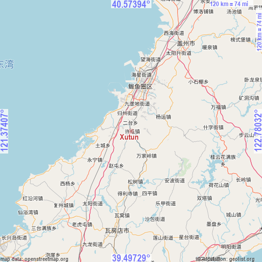
Xutun GPS coordinates[2]
40° 2' 15.864" North, 122° 4' 37.884" East
| Map corner | latitude | longitude |
|---|---|---|
| Upper-left | 40.57394°, | 121.37407° |
| Center: | 40.03774°, | 122.07719° |
| Lower-right: | 39.49729°, | 122.78032° |
| Map W x H: | 119.7×119.7 km | = 74.4×74.4mi |
| max Lat: | 53.31946° ⇑13.5% North |
| Xutun: | 40.03774° |
| min Lat: | ⇓86.5% South 18.22056° |
| min Long | Xutun | max Long |
| 75.07348° | 122.07719° | 134.28917° |
| W 91.3%⇐ | ⇒8.7% E |
Elevation
Elevation of Xutun is 40 m = 131 ft, and this is 444.8 m = 1459 ft below average elevation for this country.
| Max E: |
5622 m = 18445 ft | 73.7% |
| Avg. | 484.8 m = 1591 ft | |
| Xutun | 40 m = 131 ft | |
Min E: |
-3 m = -10 ft | 26.3% |
See also: China elevation on elevation.city.
Geographical zone
Xutun is located in North temperate zone (between Tropic of Cancer and the Arctic Circle). Distance of this Northern Tropic circle is 1845.9 km =1147 mi to South.| Distance of | km | miles | from Xutun |
|---|---|---|---|
| North Pole | 5555.3 | 3451.9 | to North |
| Arctic Circle | 2949.4 | 1832.7 | to North |
| Tropic Cancer | 1845.9 | 1147 | to South |
| Equator | 4451.8 | 2766.2 | to South |


Nearby cities:
15 places around Xutun: (largest is in red/bold)
• Guoyuan
16.7 km =10.4 mi,  18°
18°
• Haixing
26.9 km =16.7 mi,  9°
9°
• Heping
15 km =9.3 mi,  42°
42°
• Honghai
22.8 km =14.2 mi, 7°
• Jiulongdi
13.1 km =8.1 mi, 10°
• Jiuzhai
6.4 km =4 mi, 21°
• Lutun
26.9 km =16.7 mi, 20°
• Mashizhai
5.7 km =3.5 mi,  3°
3°
• Shagang
37.9 km =23.5 mi, 23°
• Shizijie
35.1 km =21.8 mi,  85°
85°
• Shuangtai
26.1 km =16.2 mi, 39°
• Wanghai
34.6 km =21.5 mi, 12°
• Xilanqi
21.4 km =13.3 mi, 15°
• Xiongyue
16 km =9.9 mi, 14°
• Yangshufang
37.8 km =23.5 mi,  53°
53°
Sources, notices
• [Note1] Compared only with cities in China existing in our database
• [Src1] Map data: © OpenStreetMap contributors (CC-BY-SA)
• [Src2] Other city data from geonames.org with taken over terms of usage.
• [Src3] Geographical zone / Annual Mean Temperature by Robert A. Rohde @ Wikipedia
