Mashizhai geodata
Mashizhai (Liaoning) is a seat of a fourth-order administrative division; located in China in Asia/Shanghai (GMT+8) time zone. In our database, there are 1268 cities with bigger population. Compared to other cities in China, 86.7% of cities are located further ↓South; 91.3% of cities are located further ←West and 71.6% of cities have higher elevation than Mashizhai. Note1


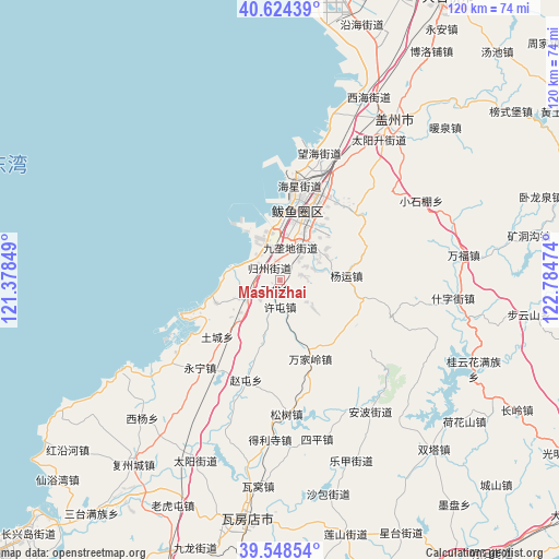
Mashizhai GPS coordinates[2]
40° 5' 18.924" North, 122° 4' 53.796" East
| Map corner | latitude | longitude |
|---|---|---|
| Upper-left | 40.62439°, | 121.37849° |
| Center: | 40.08859°, | 122.08161° |
| Lower-right: | 39.54854°, | 122.78474° |
| Map W x H: | 119.6×119.6 km | = 74.3×74.3mi |
| max Lat: | 53.31946° ⇑13.3% North |
| Mashizhai: | 40.08859° |
| min Lat: | ⇓86.7% South 18.22056° |
| min Long | Mashizhai | max Long |
| 75.07348° | 122.08161° | 134.28917° |
| W 91.3%⇐ | ⇒8.7% E |
Elevation
Elevation of Mashizhai is 46 m = 151 ft, and this is 438.8 m = 1440 ft below average elevation for this country.
| Max E: |
5622 m = 18445 ft | 71.6% |
| Avg. | 484.8 m = 1591 ft | |
| Mashizhai | 46 m = 151 ft | |
Min E: |
-3 m = -10 ft | 28.4% |
See also: China elevation on elevation.city.
Geographical zone
Mashizhai is located in North temperate zone (between Tropic of Cancer and the Arctic Circle). Distance of this Northern Tropic circle is 1851.5 km =1150.5 mi to South.| Distance of | km | miles | from Mashizhai |
|---|---|---|---|
| North Pole | 5549.6 | 3448.4 | to North |
| Arctic Circle | 2943.7 | 1829.1 | to North |
| Tropic Cancer | 1851.5 | 1150.5 | to South |
| Equator | 4457.4 | 2769.7 | to South |


Nearby cities:
15 places around Mashizhai: (largest is in red/bold)
• Guoyuan
11.3 km =7 mi,  25°
25°
• Haixing
21.3 km =13.2 mi,  11°
11°
• Heping
11.2 km =7 mi,  60°
60°
• Honghai
17.1 km =10.6 mi, 8°
• Jiulongdi
7.5 km =4.7 mi,  16°
16°
• Jiuzhai
1.9 km =1.2 mi,  81°
81°
• Lutun
21.5 km =13.4 mi, 25°
• Shagang
32.6 km =20.3 mi, 27°
• Shizijie
34.8 km =21.6 mi,  94°
94°
• Shuangtai
21.8 km =13.5 mi,  48°
48°
• Wanghai
29.1 km =18.1 mi, 14°
• Xilanqi
15.9 km =9.9 mi, 19°
• Xiongyue
10.5 km =6.5 mi, 19°
• Xutun
5.7 km =3.5 mi,  183°
183°
• Yangshufang
34.4 km =21.4 mi, 60°
Sources, notices
• [Note1] Compared only with cities in China existing in our database
• [Src1] Map data: © OpenStreetMap contributors (CC-BY-SA)
• [Src2] Other city data from geonames.org with taken over terms of usage.
• [Src3] Geographical zone / Annual Mean Temperature by Robert A. Rohde @ Wikipedia
