Tianzhuangtai geodata
Tianzhuangtai (Liaoning) is a seat of a fourth-order administrative division; located in China in Asia/Shanghai (GMT+8) time zone. In our database, there are 1268 cities with bigger population. Compared to other cities in China, 88.8% of cities are located further ↓South; 91.4% of cities are located further ←West and 98.3% of cities have higher elevation than Tianzhuangtai. Note1


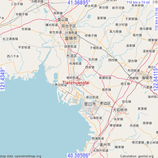
Tianzhuangtai GPS coordinates[2]
40° 50' 20.904" North, 122° 8' 16.872" East
| Map corner | latitude | longitude |
|---|---|---|
| Upper-left | 41.36895°, | 121.4349° |
| Center: | 40.83914°, | 122.13802° |
| Lower-right: | 40.30506°, | 122.84115° |
| Map W x H: | 118.3×118.3 km | = 73.5×73.5mi |
| max Lat: | 53.31946° ⇑11.2% North |
| Tianzhuangtai: | 40.83914° |
| min Lat: | ⇓88.8% South 18.22056° |
| min Long | Tianzhuangtai | max Long |
| 75.07348° | 122.13802° | 134.28917° |
| W 91.4%⇐ | ⇒8.6% E |
Elevation
Elevation of Tianzhuangtai is 4 m = 13 ft, and this is 480.8 m = 1577 ft below average elevation for this country.
| Max E: |
5622 m = 18445 ft | 98.3% |
| Avg. | 484.8 m = 1591 ft | |
| Tianzhuangtai | 4 m = 13 ft | |
Min E: |
-3 m = -10 ft | 1.7% |
See also: China elevation on elevation.city.
Geographical zone
Tianzhuangtai is located in North temperate zone (between Tropic of Cancer and the Arctic Circle). Distance of this Northern Tropic circle is 1935 km =1202.4 mi to South.| Distance of | km | miles | from Tianzhuangtai |
|---|---|---|---|
| North Pole | 5466.2 | 3396.5 | to North |
| Arctic Circle | 2860.3 | 1777.3 | to North |
| Tropic Cancer | 1935 | 1202.4 | to South |
| Equator | 4540.9 | 2821.6 | to South |


Nearby cities:
15 places around Tianzhuangtai: (largest is in red/bold)
• Dawa
18.2 km =11.3 mi,  341°
341°
• Dongfeng
18.5 km =11.5 mi,  35°
35°
• Erjiegou
5.1 km =3.2 mi,  284°
284°
• Gouyan
9.3 km =5.8 mi,  103°
103°
• Jianli
16.6 km =10.3 mi,  75°
75°
• Ping’an
5.1 km =3.2 mi,  19°
19°
• Qinghua
20.4 km =12.7 mi,  162°
162°
• Rongxing
8.1 km =5 mi,  213°
213°
• Shengli
19.6 km =12.2 mi, 159°
• Shuiyuan
3.8 km =2.4 mi,  167°
167°
• Wangjia
14 km =8.7 mi,  332°
332°
• Xinjian
18.6 km =11.6 mi,  86°
86°
• Xinxing
16.7 km =10.4 mi,  143°
143°
• Xi’an
12.3 km =7.6 mi, 41°
• Zhaoquanhe
18 km =11.2 mi,  317°
317°
Sources, notices
• [Note1] Compared only with cities in China existing in our database
• [Src1] Map data: © OpenStreetMap contributors (CC-BY-SA)
• [Src2] Other city data from geonames.org with taken over terms of usage.
• [Src3] Geographical zone / Annual Mean Temperature by Robert A. Rohde @ Wikipedia
