Xi’an geodata
Xi’an (Liaoning) is a seat of a fourth-order administrative division; located in China in Asia/Shanghai (GMT+8) time zone. In our database, there are 1268 cities with bigger population. Compared to other cities in China, 89% of cities are located further ↓South; 91.6% of cities are located further ←West and 97.2% of cities have higher elevation than Xi’an. Note1


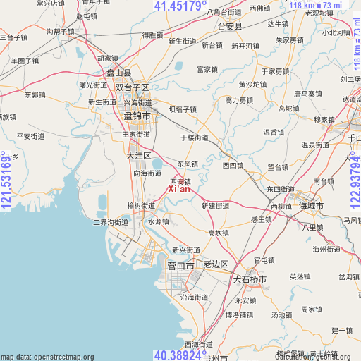
Xi’an GPS coordinates[2]
40° 55' 21.54" North, 122° 14' 5.316" East
| Map corner | latitude | longitude |
|---|---|---|
| Upper-left | 41.45179°, | 121.53169° |
| Center: | 40.92265°, | 122.23481° |
| Lower-right: | 40.38924°, | 122.93794° |
| Map W x H: | 118.1×118.1 km | = 73.4×73.4mi |
| max Lat: | 53.31946° ⇑11% North |
| Xi’an: | 40.92265° |
| min Lat: | ⇓89% South 18.22056° |
| min Long | Xi’an | max Long |
| 75.07348° | 122.23481° | 134.28917° |
| W 91.6%⇐ | ⇒8.4% E |
Elevation
Elevation of Xi’an is 5 m = 16 ft, and this is 479.8 m = 1574 ft below average elevation for this country.
| Max E: |
5622 m = 18445 ft | 97.2% |
| Avg. | 484.8 m = 1591 ft | |
| Xi’an | 5 m = 16 ft | |
Min E: |
-3 m = -10 ft | 2.8% |
See also: China elevation on elevation.city.
Geographical zone
Xi’an is located in North temperate zone (between Tropic of Cancer and the Arctic Circle). Distance of this Northern Tropic circle is 1944.3 km =1208.1 mi to South.| Distance of | km | miles | from Xi’an |
|---|---|---|---|
| North Pole | 5456.9 | 3390.8 | to North |
| Arctic Circle | 2851 | 1771.5 | to North |
| Tropic Cancer | 1944.3 | 1208.1 | to South |
| Equator | 4550.2 | 2827.4 | to South |


Nearby cities:
15 places around Xi’an: (largest is in red/bold)
• Dawa
16.1 km =10 mi,  299°
299°
• Dongfeng
6.4 km =4 mi,  24°
24°
• Erjiegou
15.3 km =9.5 mi,  238°
238°
• Gaokan
20.3 km =12.6 mi,  144°
144°
• Gouyan
11.6 km =7.2 mi,  175°
175°
• Jianli
9.4 km =5.8 mi,  122°
122°
• Ping’an
7.8 km =4.8 mi, 235°
• Qikou
17.5 km =10.9 mi, 115°
• Rongxing
20.4 km =12.7 mi,  218°
218°
• Shuiyuan
14.9 km =9.3 mi,  209°
209°
• Tianzhuangtai
12.3 km =7.6 mi, 221°
• Wangjia
14.8 km =9.2 mi,  282°
282°
• Xinjian
13.2 km =8.2 mi,  127°
127°
• Xisi
18.6 km =11.6 mi,  74°
74°
• Zhaoquanhe
20.6 km =12.8 mi, 281°
Sources, notices
• [Note1] Compared only with cities in China existing in our database
• [Src1] Map data: © OpenStreetMap contributors (CC-BY-SA)
• [Src2] Other city data from geonames.org with taken over terms of usage.
• [Src3] Geographical zone / Annual Mean Temperature by Robert A. Rohde @ Wikipedia
