Shaheying geodata
Shaheying (Liaoning) is a seat of a fourth-order administrative division; located in China in Asia/Shanghai (GMT+8) time zone. In our database, there are 1268 cities with bigger population. Compared to other cities in China, 88.8% of cities are located further ↓South; 86.6% of cities are located further ←West and 71.6% of cities have higher elevation than Shaheying. Note1


Shaheying GPS coordinates[2]
40° 49' 30.936" North, 120° 45' 47.916" East
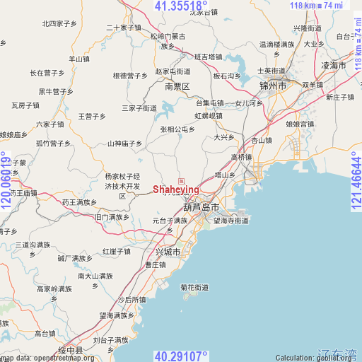
| Map corner | latitude | longitude |
|---|---|---|
| Upper-left | 41.35518°, | 120.06019° |
| Center: | 40.82526°, | 120.76331° |
| Lower-right: | 40.29107°, | 121.46644° |
| Map W x H: | 118.3×118.3 km | = 73.5×73.5mi |
| max Lat: | 53.31946° ⇑11.2% North |
| Shaheying: | 40.82526° |
| min Lat: | ⇓88.8% South 18.22056° |
| min Long | Shaheying | max Long |
| 75.07348° | 120.76331° | 134.28917° |
| W 86.6%⇐ | ⇒13.4% E |
Elevation
Elevation of Shaheying is 46 m = 151 ft, and this is 438.8 m = 1440 ft below average elevation for this country.
| Max E: |
5622 m = 18445 ft | 71.6% |
| Avg. | 484.8 m = 1591 ft | |
| Shaheying | 46 m = 151 ft | |
Min E: |
-3 m = -10 ft | 28.4% |
See also: China elevation on elevation.city.
Geographical zone
Shaheying is located in North temperate zone (between Tropic of Cancer and the Arctic Circle). Distance of this Northern Tropic circle is 1933.4 km =1201.4 mi to South.| Distance of | km | miles | from Shaheying |
|---|---|---|---|
| North Pole | 5467.7 | 3397.5 | to North |
| Arctic Circle | 2861.8 | 1778.2 | to North |
| Tropic Cancer | 1933.4 | 1201.4 | to South |
| Equator | 4539.3 | 2820.6 | to South |


Nearby cities:
15 places around Shaheying: (largest is in red/bold)
• Cishan
14.7 km =9.1 mi,  127°
127°
• Dabaimashi
13.6 km =8.5 mi,  119°
119°
• Daxing
21.7 km =13.5 mi,  43°
43°
• Gangtun
16.2 km =10.1 mi,  310°
310°
• Gaoqiao
21.3 km =13.2 mi,  67°
67°
• Heiiyugou
17.8 km =11.1 mi,  262°
262°
• Huludao
10.1 km =6.3 mi,  143°
143°
• Jinjiao
11.4 km =7.1 mi, 141°
• Lianshan
10.2 km =6.3 mi, 131°
• Longgang
17.9 km =11.1 mi, 130°
• Maoqitun
18.5 km =11.5 mi, 263°
• Shanxi
22.4 km =13.9 mi,  304°
304°
• Si’erbao
3.8 km =2.4 mi,  213°
213°
• Yingta
14.7 km =9.1 mi,  81°
81°
• Yuhuang
14.6 km =9.1 mi, 135°
Sources, notices
• [Note1] Compared only with cities in China existing in our database
• [Src1] Map data: © OpenStreetMap contributors (CC-BY-SA)
• [Src2] Other city data from geonames.org with taken over terms of usage.
• [Src3] Geographical zone / Annual Mean Temperature by Robert A. Rohde @ Wikipedia
