Na’erhong geodata
Na’erhong (Jilin) is a seat of a fourth-order administrative division; located in China in Asia/Shanghai (GMT+8) time zone. In our database, there are 1268 cities with bigger population. Compared to other cities in China, 91.6% of cities are located further ↓South; 96.7% of cities are located further ←West and 70.4% of cities have lower elevation than Na’erhong. Note1


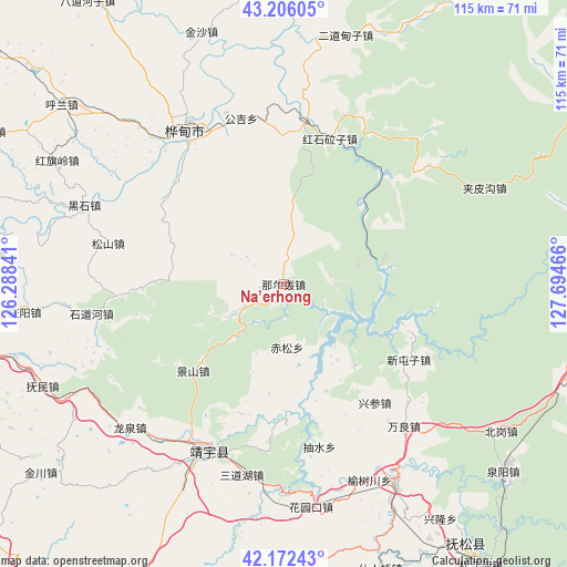
Na’erhong GPS coordinates[2]
42° 41' 29.004" North, 126° 59' 29.508" East
| Map corner | latitude | longitude |
|---|---|---|
| Upper-left | 43.20605°, | 126.28841° |
| Center: | 42.69139°, | 126.99153° |
| Lower-right: | 42.17243°, | 127.69466° |
| Map W x H: | 114.9×114.9 km | = 71.4×71.4mi |
| max Lat: | 53.31946° ⇑8.4% North |
| Na’erhong: | 42.69139° |
| min Lat: | ⇓91.6% South 18.22056° |
| min Long | Na’erhong | max Long |
| 75.07348° | 126.99153° | 134.28917° |
| W 96.7%⇐ | ⇒3.3% E |
Elevation
Elevation of Na’erhong is 419 m = 1375 ft, and this is 65.8 m = 216 ft below average elevation for this country.
| Max E: |
5622 m = 18445 ft | 29.6% |
| Avg. | 484.8 m = 1591 ft | |
| Na’erhong | 419 m = 1375 ft | |
Min E: |
-3 m = -10 ft | 70.4% |
See also: China elevation on elevation.city.
Geographical zone
Na’erhong is located in North temperate zone (between Tropic of Cancer and the Arctic Circle). Distance of this Northern Tropic circle is 2140.9 km =1330.3 mi to South.| Distance of | km | miles | from Na’erhong |
|---|---|---|---|
| North Pole | 5260.2 | 3268.5 | to North |
| Arctic Circle | 2654.3 | 1649.3 | to North |
| Tropic Cancer | 2140.9 | 1330.3 | to South |
| Equator | 4746.8 | 2949.5 | to South |


Nearby cities:
15 places around Na’erhong: (largest is in red/bold)
• Baishan
20.4 km =12.7 mi,  76°
76°
• Chisong
12.4 km =7.7 mi,  174°
174°
• Choushui
33.7 km =20.9 mi, 168°
• Dujia
9.2 km =5.7 mi,  240°
240°
• Gongji
34.8 km =21.6 mi,  345°
345°
• Hongshi
30.8 km =19.1 mi,  16°
16°
• Huadian
36.2 km =22.5 mi,  326°
326°
• Huangni
29.1 km =18.1 mi,  121°
121°
• Jingyu
38.7 km =24 mi,  203°
203°
• Jinjiadian
39.6 km =24.6 mi,  192°
192°
• Jiujianfang
32.3 km =20.1 mi,  339°
339°
• Laojinchang
38.1 km =23.7 mi,  50°
50°
• Wanliang
37.7 km =23.4 mi,  139°
139°
• Xingcan
30.2 km =18.8 mi, 141°
• Yushu
22.2 km =13.8 mi, 139°
Sources, notices
• [Note1] Compared only with cities in China existing in our database
• [Src1] Map data: © OpenStreetMap contributors (CC-BY-SA)
• [Src2] Other city data from geonames.org with taken over terms of usage.
• [Src3] Geographical zone / Annual Mean Temperature by Robert A. Rohde @ Wikipedia
