Biancheng geodata
Biancheng (Liaoning) is a seat of a third-order administrative division; located in China in Asia/Shanghai (GMT+8) time zone. In our database, there are 1268 cities with bigger population. Compared to other cities in China, 88.5% of cities are located further ↓South; 91.8% of cities are located further ←West and 98.3% of cities have higher elevation than Biancheng. Note1


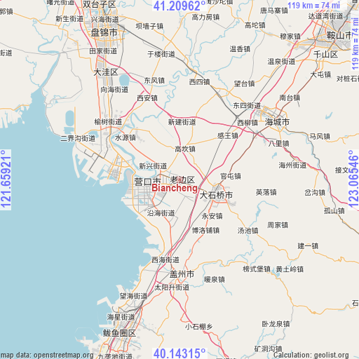
Biancheng GPS coordinates[2]
40° 40' 42.672" North, 122° 21' 44.388" East
| Map corner | latitude | longitude |
|---|---|---|
| Upper-left | 41.20962°, | 121.65921° |
| Center: | 40.67852°, | 122.36233° |
| Lower-right: | 40.14315°, | 123.06546° |
| Map W x H: | 118.6×118.6 km | = 73.7×73.7mi |
| max Lat: | 53.31946° ⇑11.5% North |
| Biancheng: | 40.67852° |
| min Lat: | ⇓88.5% South 18.22056° |
| min Long | Biancheng | max Long |
| 75.07348° | 122.36233° | 134.28917° |
| W 91.8%⇐ | ⇒8.2% E |
Elevation
Elevation of Biancheng is 4 m = 13 ft, and this is 480.8 m = 1577 ft below average elevation for this country.
| Max E: |
5622 m = 18445 ft | 98.3% |
| Avg. | 484.8 m = 1591 ft | |
| Biancheng | 4 m = 13 ft | |
Min E: |
-3 m = -10 ft | 1.7% |
See also: China elevation on elevation.city.
Geographical zone
Biancheng is located in North temperate zone (between Tropic of Cancer and the Arctic Circle). Distance of this Northern Tropic circle is 1917.1 km =1191.2 mi to South.| Distance of | km | miles | from Biancheng |
|---|---|---|---|
| North Pole | 5484 | 3407.6 | to North |
| Arctic Circle | 2878.1 | 1788.4 | to North |
| Tropic Cancer | 1917.1 | 1191.2 | to South |
| Equator | 4523 | 2810.5 | to South |


Nearby cities:
15 places around Biancheng: (largest is in red/bold)
• Chengdong
4.1 km =2.5 mi,  122°
122°
• Dashiqiao
12.7 km =7.9 mi,  111°
111°
• Erdao
12.2 km =7.6 mi,  221°
221°
• Gangdu
13.4 km =8.3 mi, 109°
• Gaokan
10.6 km =6.6 mi,  5°
5°
• Jianfeng
10.5 km =6.5 mi,  264°
264°
• Jinqiao
11.3 km =7 mi, 116°
• Liushu
8.5 km =5.3 mi,  148°
148°
• Lunan
5.3 km =3.3 mi,  281°
281°
• Qinghua
12.8 km =8 mi, 262°
• Shengli
12.2 km =7.6 mi,  267°
267°
• Shiqiao
12.3 km =7.6 mi, 112°
• Xinxing
10 km =6.2 mi,  296°
296°
• Yingkou
11.4 km =7.1 mi, 262°
• Yuejin
8.9 km =5.5 mi, 266°
Sources, notices
• [Note1] Compared only with cities in China existing in our database
• [Src1] Map data: © OpenStreetMap contributors (CC-BY-SA)
• [Src2] Other city data from geonames.org with taken over terms of usage.
• [Src3] Geographical zone / Annual Mean Temperature by Robert A. Rohde @ Wikipedia
