Liushu geodata
Liushu (Liaoning) is a seat of a fourth-order administrative division; located in China in Asia/Shanghai (GMT+8) time zone. In our database, there are 1268 cities with bigger population. Compared to other cities in China, 88.3% of cities are located further ↓South; 92% of cities are located further ←West and 94.3% of cities have higher elevation than Liushu. Note1


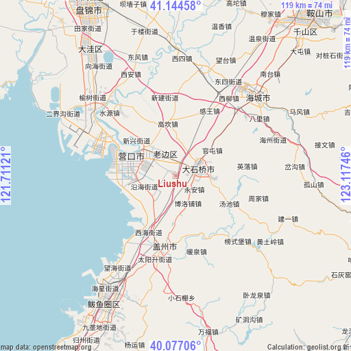
Liushu GPS coordinates[2]
40° 36' 46.62" North, 122° 24' 51.588" East
| Map corner | latitude | longitude |
|---|---|---|
| Upper-left | 41.14458°, | 121.71121° |
| Center: | 40.61295°, | 122.41433° |
| Lower-right: | 40.07706°, | 123.11746° |
| Map W x H: | 118.7×118.7 km | = 73.8×73.8mi |
| max Lat: | 53.31946° ⇑11.7% North |
| Liushu: | 40.61295° |
| min Lat: | ⇓88.3% South 18.22056° |
| min Long | Liushu | max Long |
| 75.07348° | 122.41433° | 134.28917° |
| W 92%⇐ | ⇒8% E |
Elevation
Elevation of Liushu is 7 m = 23 ft, and this is 477.8 m = 1568 ft below average elevation for this country.
| Max E: |
5622 m = 18445 ft | 94.3% |
| Avg. | 484.8 m = 1591 ft | |
| Liushu | 7 m = 23 ft | |
Min E: |
-3 m = -10 ft | 5.7% |
See also: China elevation on elevation.city.
Geographical zone
Liushu is located in North temperate zone (between Tropic of Cancer and the Arctic Circle). Distance of this Northern Tropic circle is 1909.8 km =1186.7 mi to South.| Distance of | km | miles | from Liushu |
|---|---|---|---|
| North Pole | 5491.3 | 3412.1 | to North |
| Arctic Circle | 2885.4 | 1792.9 | to North |
| Tropic Cancer | 1909.8 | 1186.7 | to South |
| Equator | 4515.7 | 2805.9 | to South |


Nearby cities:
15 places around Liushu: (largest is in red/bold)
• Biancheng
8.5 km =5.3 mi,  328°
328°
• Boluopu
10.1 km =6.3 mi,  157°
157°
• Chengdong
5.1 km =3.2 mi,  349°
349°
• Dashiqiao
7.9 km =4.9 mi,  69°
69°
• Erdao
12.6 km =7.8 mi,  261°
261°
• Gangdu
8.8 km =5.5 mi, 70°
• Guantun
14.7 km =9.1 mi,  56°
56°
• Huzhuang
15.7 km =9.8 mi,  42°
42°
• Jianfeng
16.1 km =10 mi,  292°
292°
• Jinqiao
6.1 km =3.8 mi, 68°
• Lunan
12.7 km =7.9 mi,  311°
311°
• Qingshiling
15.3 km =9.5 mi,  180°
180°
• Shiqiao
7.5 km =4.7 mi, 69°
• Yong’an
8 km =5 mi,  125°
125°
• Yuejin
14.9 km =9.3 mi,  296°
296°
Sources, notices
• [Note1] Compared only with cities in China existing in our database
• [Src1] Map data: © OpenStreetMap contributors (CC-BY-SA)
• [Src2] Other city data from geonames.org with taken over terms of usage.
• [Src3] Geographical zone / Annual Mean Temperature by Robert A. Rohde @ Wikipedia
