Huifa geodata
Huifa (Heilongjiang) is a seat of a fourth-order administrative division; located in China in Asia/Shanghai (GMT+8) time zone. In our database, there are 1268 cities with bigger population. Compared to other cities in China, 94.7% of cities are located further ↓South; 98.2% of cities are located further ←West and 56.7% of cities have higher elevation than Huifa. Note1


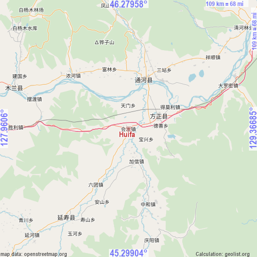
Huifa GPS coordinates[2]
45° 47' 29.292" North, 128° 39' 49.392" East
| Map corner | latitude | longitude |
|---|---|---|
| Upper-left | 46.27958°, | 127.9606° |
| Center: | 45.79147°, | 128.66372° |
| Lower-right: | 45.29904°, | 129.36685° |
| Map W x H: | 109×109 km | = 67.7×67.7mi |
| max Lat: | 53.31946° ⇑5.3% North |
| Huifa: | 45.79147° |
| min Lat: | ⇓94.7% South 18.22056° |
| min Long | Huifa | max Long |
| 75.07348° | 128.66372° | 134.28917° |
| W 98.2%⇐ | ⇒1.8% E |
Elevation
Elevation of Huifa is 119 m = 390 ft, and this is 365.8 m = 1200 ft below average elevation for this country.
| Max E: |
5622 m = 18445 ft | 56.7% |
| Avg. | 484.8 m = 1591 ft | |
| Huifa | 119 m = 390 ft | |
Min E: |
-3 m = -10 ft | 43.3% |
See also: China elevation on elevation.city.
Geographical zone
Huifa is located in North temperate zone (between Tropic of Cancer and the Arctic Circle). Distance of this North polar circle is 2309.6 km =1435.1 mi to North.| Distance of | km | miles | from Huifa |
|---|---|---|---|
| North Pole | 4915.5 | 3054.3 | to North |
| Arctic Circle | 2309.6 | 1435.1 | to North |
| Tropic Cancer | 2485.6 | 1544.5 | to South |
| Equator | 5091.5 | 3163.7 | to South |


Nearby cities:
15 places around Huifa: (largest is in red/bold)
• Anshan
33.1 km =20.6 mi,  199°
199°
• Baoxing
8.7 km =5.4 mi,  119°
119°
• Daluomi
45.8 km =28.5 mi,  66°
66°
• Fangzheng
13.7 km =8.5 mi, 67°
• Jiaxin
14.3 km =8.9 mi,  165°
165°
• Liutuan
27.4 km =17 mi,  210°
210°
• Nonghe
32.6 km =20.3 mi,  313°
313°
• Shanhecun
11 km =6.8 mi,  215°
215°
• Shoushan
42.2 km =26.2 mi, 204°
• Songnan
14.2 km =8.8 mi,  48°
48°
• Tianmen
10 km =6.2 mi,  0°
0°
• Tonghe
21.4 km =13.3 mi,  16°
16°
• Wuyapao
24.9 km =15.5 mi,  34°
34°
• Yihantong
20.3 km =12.6 mi,  62°
62°
• Zhonghe
32.9 km =20.4 mi, 165°
Sources, notices
• [Note1] Compared only with cities in China existing in our database
• [Src1] Map data: © OpenStreetMap contributors (CC-BY-SA)
• [Src2] Other city data from geonames.org with taken over terms of usage.
• [Src3] Geographical zone / Annual Mean Temperature by Robert A. Rohde @ Wikipedia
