Shoushan geodata
Shoushan (Heilongjiang) is a seat of a fourth-order administrative division; located in China in Asia/Shanghai (GMT+8) time zone. In our database, there are 1268 cities with bigger population. Compared to other cities in China, 94.3% of cities are located further ↓South; 98.1% of cities are located further ←West and 50.3% of cities have higher elevation than Shoushan. Note1


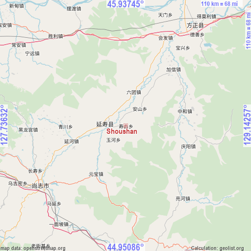
Shoushan GPS coordinates[2]
45° 26' 46.716" North, 128° 26' 21.984" East
| Map corner | latitude | longitude |
|---|---|---|
| Upper-left | 45.93745°, | 127.73632° |
| Center: | 45.44631°, | 128.43944° |
| Lower-right: | 44.95086°, | 129.14257° |
| Map W x H: | 109.7×109.7 km | = 68.2×68.2mi |
| max Lat: | 53.31946° ⇑5.7% North |
| Shoushan: | 45.44631° |
| min Lat: | ⇓94.3% South 18.22056° |
| min Long | Shoushan | max Long |
| 75.07348° | 128.43944° | 134.28917° |
| W 98.1%⇐ | ⇒1.9% E |
Elevation
Elevation of Shoushan is 162 m = 531 ft, and this is 322.8 m = 1059 ft below average elevation for this country.
| Max E: |
5622 m = 18445 ft | 50.3% |
| Avg. | 484.8 m = 1591 ft | |
| Shoushan | 162 m = 531 ft | |
Min E: |
-3 m = -10 ft | 49.7% |
See also: China elevation on elevation.city.
Geographical zone
Shoushan is located in North temperate zone (between Tropic of Cancer and the Arctic Circle). Distance of this North polar circle is 2348 km =1459 mi to North.| Distance of | km | miles | from Shoushan |
|---|---|---|---|
| North Pole | 4953.9 | 3078.2 | to North |
| Arctic Circle | 2348 | 1459 | to North |
| Tropic Cancer | 2447.2 | 1520.6 | to South |
| Equator | 5053.2 | 3139.9 | to South |


Nearby cities:
15 places around Shoushan: (largest is in red/bold)
• Anshan
9.6 km =6 mi,  40°
40°
• Baoxing
42.3 km =26.3 mi, 36°
• Hedong
38.3 km =23.8 mi,  236°
236°
• Huifa
42.2 km =26.2 mi,  24°
24°
• Jiaxin
32.4 km =20.1 mi, 40°
• Lianghe
40.5 km =25.2 mi,  141°
141°
• Liutuan
15.1 km =9.4 mi,  14°
14°
• Qingchuan
26.1 km =16.2 mi,  269°
269°
• Qingyang
28.9 km =18 mi,  107°
107°
• Shanhecun
31.4 km =19.5 mi, 20°
• Yanhe
24.5 km =15.2 mi,  254°
254°
• Yanshou
8.8 km =5.5 mi,  275°
275°
• Yuanbao
24.7 km =15.3 mi,  211°
211°
• Yuhe
8.1 km =5 mi,  222°
222°
• Zhonghe
26.7 km =16.6 mi,  75°
75°
Sources, notices
• [Note1] Compared only with cities in China existing in our database
• [Src1] Map data: © OpenStreetMap contributors (CC-BY-SA)
• [Src2] Other city data from geonames.org with taken over terms of usage.
• [Src3] Geographical zone / Annual Mean Temperature by Robert A. Rohde @ Wikipedia
