Jiuduhe geodata
Jiuduhe (Beijing) is a seat of a fourth-order administrative division; located in China in Asia/Shanghai (GMT+8) time zone. In our database, there are 1268 cities with bigger population. Compared to other cities in China, 87.6% of cities are located further ↓South; 62.8% of cities are located further ←West and 54.9% of cities have higher elevation than Jiuduhe. Note1


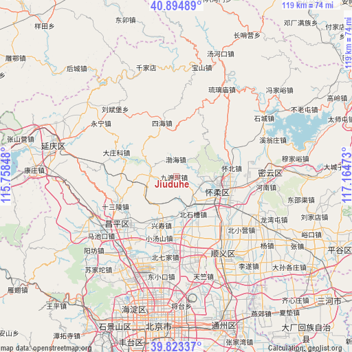
Jiuduhe GPS coordinates[2]
40° 21' 40.536" North, 116° 27' 41.76" East
| Map corner | latitude | longitude |
|---|---|---|
| Upper-left | 40.89489°, | 115.75848° |
| Center: | 40.36126°, | 116.4616° |
| Lower-right: | 39.82337°, | 117.16473° |
| Map W x H: | 119.1×119.1 km | = 74×74mi |
| max Lat: | 53.31946° ⇑12.4% North |
| Jiuduhe: | 40.36126° |
| min Lat: | ⇓87.6% South 18.22056° |
| min Long | Jiuduhe | max Long |
| 75.07348° | 116.4616° | 134.28917° |
| W 62.8%⇐ | ⇒37.2% E |
Elevation
Elevation of Jiuduhe is 132 m = 433 ft, and this is 352.8 m = 1157 ft below average elevation for this country.
| Max E: |
5622 m = 18445 ft | 54.9% |
| Avg. | 484.8 m = 1591 ft | |
| Jiuduhe | 132 m = 433 ft | |
Min E: |
-3 m = -10 ft | 45.1% |
See also: China elevation on elevation.city.
Geographical zone
Jiuduhe is located in North temperate zone (between Tropic of Cancer and the Arctic Circle). Distance of this Northern Tropic circle is 1881.8 km =1169.3 mi to South.| Distance of | km | miles | from Jiuduhe |
|---|---|---|---|
| North Pole | 5519.3 | 3429.5 | to North |
| Arctic Circle | 2913.4 | 1810.3 | to North |
| Tropic Cancer | 1881.8 | 1169.3 | to South |
| Equator | 4487.8 | 2788.6 | to South |


Nearby cities:
15 places around Jiuduhe: (largest is in red/bold)
• Beifang
19.6 km =12.2 mi,  102°
102°
• Beishicao
13.7 km =8.5 mi,  157°
157°
• Bohai
5.7 km =3.5 mi,  5°
5°
• Changling
19.5 km =12.1 mi,  247°
247°
• Cuicun
18.4 km =11.4 mi,  210°
210°
• Gaoliying
21.4 km =13.3 mi,  172°
172°
• Huaibei
20 km =12.4 mi,  80°
80°
• Longshan
14.9 km =9.3 mi,  107°
107°
• Miaocheng
15.7 km =9.8 mi,  119°
119°
• Qiaozi
12.3 km =7.6 mi,  130°
130°
• Sihai
18.8 km =11.7 mi,  345°
345°
• Xiaotangshan
21.5 km =13.4 mi,  197°
197°
• Xingshou
16.4 km =10.2 mi, 196°
• Yangsong
19.8 km =12.3 mi, 111°
• Yanqi
16.5 km =10.3 mi,  89°
89°
Sources, notices
• [Note1] Compared only with cities in China existing in our database
• [Src1] Map data: © OpenStreetMap contributors (CC-BY-SA)
• [Src2] Other city data from geonames.org with taken over terms of usage.
• [Src3] Geographical zone / Annual Mean Temperature by Robert A. Rohde @ Wikipedia
