Gucheng geodata
Gucheng (Heilongjiang) is a seat of a fourth-order administrative division; located in China in Asia/Shanghai (GMT+8) time zone. In our database, there are 1268 cities with bigger population. Compared to other cities in China, 98.5% of cities are located further ↓South; 95.2% of cities are located further ←West and 56.6% of cities have lower elevation than Gucheng. Note1


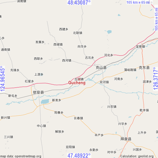
Gucheng GPS coordinates[2]
47° 57' 43.884" North, 125° 40' 6.852" East
| Map corner | latitude | longitude |
|---|---|---|
| Upper-left | 48.43087°, | 124.96545° |
| Center: | 47.96219°, | 125.66857° |
| Lower-right: | 47.48922°, | 126.3717° |
| Map W x H: | 104.7×104.7 km | = 65.1×65.1mi |
| max Lat: | 53.31946° ⇑1.5% North |
| Gucheng: | 47.96219° |
| min Lat: | ⇓98.5% South 18.22056° |
| min Long | Gucheng | max Long |
| 75.07348° | 125.66857° | 134.28917° |
| W 95.2%⇐ | ⇒4.8% E |
Elevation
Elevation of Gucheng is 222 m = 728 ft, and this is 262.8 m = 862 ft below average elevation for this country.
| Max E: |
5622 m = 18445 ft | 43.4% |
| Avg. | 484.8 m = 1591 ft | |
| Gucheng | 222 m = 728 ft | |
Min E: |
-3 m = -10 ft | 56.6% |
See also: China elevation on elevation.city.
Geographical zone
Gucheng is located in North temperate zone (between Tropic of Cancer and the Arctic Circle). Distance of this North polar circle is 2068.3 km =1285.2 mi to North.| Distance of | km | miles | from Gucheng |
|---|---|---|---|
| North Pole | 4674.2 | 2904.4 | to North |
| Arctic Circle | 2068.3 | 1285.2 | to North |
| Tropic Cancer | 2727 | 1694.5 | to South |
| Equator | 5332.9 | 3313.7 | to South |


Nearby cities:
15 places around Gucheng: (largest is in red/bold)
• Changchun
25.6 km =15.9 mi,  181°
181°
• Dazhong
24 km =14.9 mi,  141°
141°
• Fengchan
39.4 km =24.5 mi,  160°
160°
• Henan
26.1 km =16.2 mi,  89°
89°
• Hongxing
33 km =20.5 mi,  267°
267°
• Jianguo
34.5 km =21.4 mi,  117°
117°
• Jiefang
37.2 km =23.1 mi,  200°
200°
• Shangyou
26.1 km =16.2 mi, 270°
• Shuanghe
16.6 km =10.3 mi,  96°
96°
• Taidong
16.7 km =10.4 mi,  245°
245°
• Xinfa
20.3 km =12.6 mi,  227°
227°
• Xingnong
28.1 km =17.5 mi,  129°
129°
• Xinjian
17.9 km =11.1 mi, 181°
• Yangchun
25.7 km =16 mi,  210°
210°
• Yi’an
28.4 km =17.6 mi, 253°
Sources, notices
• [Note1] Compared only with cities in China existing in our database
• [Src1] Map data: © OpenStreetMap contributors (CC-BY-SA)
• [Src2] Other city data from geonames.org with taken over terms of usage.
• [Src3] Geographical zone / Annual Mean Temperature by Robert A. Rohde @ Wikipedia
