Henan geodata
Henan (Heilongjiang) is a seat of a fourth-order administrative division; located in China in Asia/Shanghai (GMT+8) time zone. In our database, there are 1268 cities with bigger population. Compared to other cities in China, 98.6% of cities are located further ↓South; 95.6% of cities are located further ←West and 61.3% of cities have lower elevation than Henan. Note1


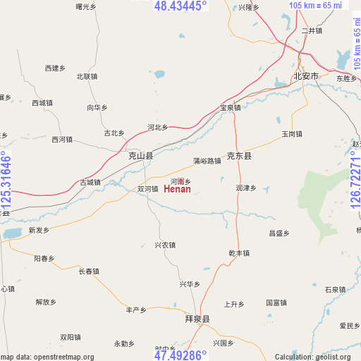
Henan GPS coordinates[2]
47° 57' 56.88" North, 126° 1' 10.488" East
| Map corner | latitude | longitude |
|---|---|---|
| Upper-left | 48.43445°, | 125.31646° |
| Center: | 47.9658°, | 126.01958° |
| Lower-right: | 47.49286°, | 126.72271° |
| Map W x H: | 104.7×104.7 km | = 65.1×65.1mi |
| max Lat: | 53.31946° ⇑1.4% North |
| Henan: | 47.9658° |
| min Lat: | ⇓98.6% South 18.22056° |
| min Long | Henan | max Long |
| 75.07348° | 126.01958° | 134.28917° |
| W 95.6%⇐ | ⇒4.4% E |
Elevation
Elevation of Henan is 275 m = 902 ft, and this is 209.8 m = 688 ft below average elevation for this country.
| Max E: |
5622 m = 18445 ft | 38.7% |
| Avg. | 484.8 m = 1591 ft | |
| Henan | 275 m = 902 ft | |
Min E: |
-3 m = -10 ft | 61.3% |
See also: China elevation on elevation.city.
Geographical zone
Henan is located in North temperate zone (between Tropic of Cancer and the Arctic Circle). Distance of this North polar circle is 2067.9 km =1284.9 mi to North.| Distance of | km | miles | from Henan |
|---|---|---|---|
| North Pole | 4673.8 | 2904.2 | to North |
| Arctic Circle | 2067.9 | 1284.9 | to North |
| Tropic Cancer | 2727.4 | 1694.7 | to South |
| Equator | 5333.3 | 3314 | to South |


Nearby cities:
15 places around Henan: (largest is in red/bold)
• Aiguo
36.2 km =22.5 mi,  127°
127°
• Baoquan
25.6 km =15.9 mi,  33°
33°
• Changchun
37.4 km =23.2 mi,  225°
225°
• Changsheng
32.5 km =20.2 mi,  117°
117°
• Dazhong
22.2 km =13.8 mi,  210°
210°
• Gucheng
26.1 km =16.2 mi,  269°
269°
• Jianguo
16.8 km =10.4 mi,  164°
164°
• Mingshan
21.7 km =13.5 mi,  47°
47°
• Qianfeng
26.9 km =16.7 mi,  141°
141°
• Runjin
19.1 km =11.9 mi,  95°
95°
• Shuanghe
9.9 km =6.2 mi,  257°
257°
• Shuangqing
28 km =17.4 mi,  90°
90°
• Xinghua
30.1 km =18.7 mi,  175°
175°
• Xingnong
19 km =11.8 mi,  194°
194°
• Xinjian
32.3 km =20.1 mi,  235°
235°
Sources, notices
• [Note1] Compared only with cities in China existing in our database
• [Src1] Map data: © OpenStreetMap contributors (CC-BY-SA)
• [Src2] Other city data from geonames.org with taken over terms of usage.
• [Src3] Geographical zone / Annual Mean Temperature by Robert A. Rohde @ Wikipedia
