Lianhua geodata
Lianhua (Hunan) is a seat of a fourth-order administrative division; located in China in Asia/Shanghai (GMT+8) time zone. In our database, there are 1268 cities with bigger population. Compared to other cities in China, 82.6% of cities are located further ↑North; 61.3% of cities are located further →East and 59.6% of cities have lower elevation than Lianhua. Note1


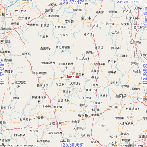
Lianhua GPS coordinates[2]
25° 56' 36.996" North, 112° 16' 39" East
| Map corner | latitude | longitude |
|---|---|---|
| Upper-left | 26.57417°, | 111.57438° |
| Center: | 25.94361°, | 112.2775° |
| Lower-right: | 25.30966°, | 112.98063° |
| Map W x H: | 140.6×140.6 km | = 87.4×87.4mi |
| max Lat: | 53.31946° ⇑82.6% North |
| Lianhua: | 25.94361° |
| min Lat: | ⇓17.4% South 18.22056° |
| min Long | Lianhua | max Long |
| 75.07348° | 112.2775° | 134.28917° |
| W 38.7%⇐ | ⇒61.3% E |
Elevation
Elevation of Lianhua is 255 m = 837 ft, and this is 229.8 m = 754 ft below average elevation for this country.
| Max E: |
5622 m = 18445 ft | 40.4% |
| Avg. | 484.8 m = 1591 ft | |
| Lianhua | 255 m = 837 ft | |
Min E: |
-3 m = -10 ft | 59.6% |
See also: China elevation on elevation.city.
Geographical zone
Lianhua is located in North temperate zone (between Tropic of Cancer and the Arctic Circle). Distance of this Northern Tropic circle is 278.7 km =173.2 mi to South.| Distance of | km | miles | from Lianhua |
|---|---|---|---|
| North Pole | 7122.4 | 4425.7 | to North |
| Arctic Circle | 4516.5 | 2806.4 | to North |
| Tropic Cancer | 278.7 | 173.2 | to South |
| Equator | 2884.7 | 1792.5 | to South |


Nearby cities:
15 places around Lianhua: (largest is in red/bold)
• Bao’an
31 km =19.3 mi,  219°
219°
• Gaoshan
17.9 km =11.1 mi,  168°
168°
• Huangtang
26.5 km =16.5 mi,  293°
293°
• Jicun
12.4 km =7.7 mi,  276°
276°
• Lengshuijing
16.8 km =10.4 mi,  269°
269°
• Longquan
8.1 km =5 mi,  234°
234°
• Maojia
14.3 km =8.9 mi,  212°
212°
• Maoli
16.6 km =10.3 mi, 233°
• Menlouxia
10.6 km =6.6 mi,  318°
318°
• Sanjing
18.4 km =11.4 mi,  201°
201°
• Shiyang
21.7 km =13.5 mi,  191°
191°
• Shizi
25.6 km =15.9 mi, 218°
• Taoling
22.9 km =14.2 mi, 169°
• Xinlong
18.9 km =11.7 mi,  157°
157°
• Xinxu
15.7 km =9.8 mi,  182°
182°
Sources, notices
• [Note1] Compared only with cities in China existing in our database
• [Src1] Map data: © OpenStreetMap contributors (CC-BY-SA)
• [Src2] Other city data from geonames.org with taken over terms of usage.
• [Src3] Geographical zone / Annual Mean Temperature by Robert A. Rohde @ Wikipedia
