Shiyang geodata
Shiyang (Hunan) is a seat of a fourth-order administrative division; located in China in Asia/Shanghai (GMT+8) time zone. In our database, there are 1268 cities with bigger population. Compared to other cities in China, 83.3% of cities are located further ↑North; 61.4% of cities are located further →East and 57.2% of cities have lower elevation than Shiyang. Note1


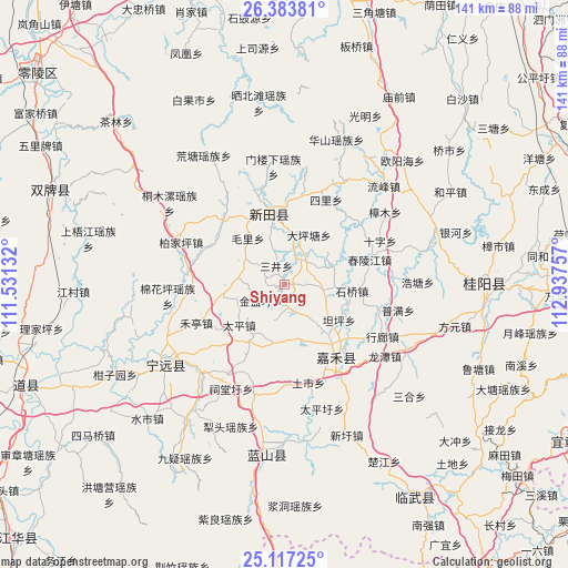
Shiyang GPS coordinates[2]
25° 45' 7.992" North, 112° 14' 3.984" East
| Map corner | latitude | longitude |
|---|---|---|
| Upper-left | 26.38381°, | 111.53132° |
| Center: | 25.75222°, | 112.23444° |
| Lower-right: | 25.11725°, | 112.93757° |
| Map W x H: | 140.8×140.8 km | = 87.5×87.5mi |
| max Lat: | 53.31946° ⇑83.3% North |
| Shiyang: | 25.75222° |
| min Lat: | ⇓16.7% South 18.22056° |
| min Long | Shiyang | max Long |
| 75.07348° | 112.23444° | 134.28917° |
| W 38.6%⇐ | ⇒61.4% E |
Elevation
Elevation of Shiyang is 227 m = 745 ft, and this is 257.8 m = 846 ft below average elevation for this country.
| Max E: |
5622 m = 18445 ft | 42.8% |
| Avg. | 484.8 m = 1591 ft | |
| Shiyang | 227 m = 745 ft | |
Min E: |
-3 m = -10 ft | 57.2% |
See also: China elevation on elevation.city.
Geographical zone
Shiyang is located in North temperate zone (between Tropic of Cancer and the Arctic Circle). Distance of this Northern Tropic circle is 257.5 km =160 mi to South.| Distance of | km | miles | from Shiyang |
|---|---|---|---|
| North Pole | 7143.7 | 4438.9 | to North |
| Arctic Circle | 4537.8 | 2819.7 | to North |
| Tropic Cancer | 257.5 | 160 | to South |
| Equator | 2863.4 | 1779.2 | to South |


Nearby cities:
15 places around Shiyang: (largest is in red/bold)
• Bao’an
15.5 km =9.6 mi,  259°
259°
• Gaoshan
8.9 km =5.5 mi,  64°
64°
• Heting
24 km =14.9 mi,  245°
245°
• Jicun
24.1 km =15 mi,  340°
340°
• Lengshuijing
24.5 km =15.2 mi,  329°
329°
• Lianhua
21.7 km =13.5 mi,  11°
11°
• Longquan
16.7 km =10.4 mi,  352°
352°
• Maojia
9.8 km =6.1 mi, 339°
• Maoli
14.5 km =9 mi,  321°
321°
• Sanjing
4.8 km =3 mi, 329°
• Shizi
11.6 km =7.2 mi,  275°
275°
• Taiping
15.1 km =9.4 mi,  227°
227°
• Taoling
8.7 km =5.4 mi,  98°
98°
• Xinlong
12.3 km =7.6 mi,  71°
71°
• Xinxu
6.6 km =4.1 mi,  32°
32°
Sources, notices
• [Note1] Compared only with cities in China existing in our database
• [Src1] Map data: © OpenStreetMap contributors (CC-BY-SA)
• [Src2] Other city data from geonames.org with taken over terms of usage.
• [Src3] Geographical zone / Annual Mean Temperature by Robert A. Rohde @ Wikipedia
