Xiaopu geodata
Xiaopu (Hunan) is a seat of a fourth-order administrative division; located in China in Asia/Shanghai (GMT+8) time zone. In our database, there are 1268 cities with bigger population. Compared to other cities in China, 85.2% of cities are located further ↑North; 65.7% of cities are located further →East and 58.2% of cities have lower elevation than Xiaopu. Note1


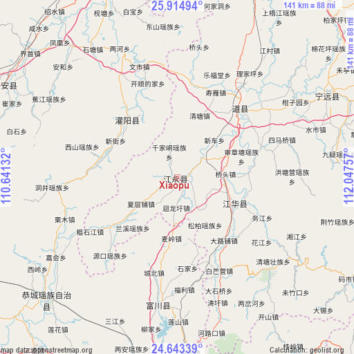
Xiaopu GPS coordinates[2]
25° 16' 50.988" North, 111° 20' 39.984" East
| Map corner | latitude | longitude |
|---|---|---|
| Upper-left | 25.91494°, | 110.64132° |
| Center: | 25.28083°, | 111.34444° |
| Lower-right: | 24.64339°, | 112.04757° |
| Map W x H: | 141.4×141.4 km | = 87.9×87.9mi |
| max Lat: | 53.31946° ⇑85.2% North |
| Xiaopu: | 25.28083° |
| min Lat: | ⇓14.8% South 18.22056° |
| min Long | Xiaopu | max Long |
| 75.07348° | 111.34444° | 134.28917° |
| W 34.3%⇐ | ⇒65.7% E |
Elevation
Elevation of Xiaopu is 238 m = 781 ft, and this is 246.8 m = 810 ft below average elevation for this country.
| Max E: |
5622 m = 18445 ft | 41.8% |
| Avg. | 484.8 m = 1591 ft | |
| Xiaopu | 238 m = 781 ft | |
Min E: |
-3 m = -10 ft | 58.2% |
See also: China elevation on elevation.city.
Geographical zone
Xiaopu is located in North temperate zone (between Tropic of Cancer and the Arctic Circle). Distance of this Northern Tropic circle is 205 km =127.4 mi to South.| Distance of | km | miles | from Xiaopu |
|---|---|---|---|
| North Pole | 7196.1 | 4471.4 | to North |
| Arctic Circle | 4590.2 | 2852.2 | to North |
| Tropic Cancer | 205 | 127.4 | to South |
| Equator | 2811 | 1746.7 | to South |


Nearby cities:
15 places around Xiaopu: (largest is in red/bold)
• Daojiang
31.7 km =19.7 mi,  40°
40°
• Daojiang
36.7 km =22.8 mi, 40°
• Dongtian
34 km =21.1 mi,  115°
115°
• Guanyang
31.8 km =19.8 mi,  318°
318°
• Lanxi
27.7 km =17.2 mi,  222°
222°
• Qianjiadong
10.3 km =6.4 mi,  348°
348°
• Qiaotou
19.4 km =12.1 mi,  86°
86°
• Shangjiangxu
11.8 km =7.3 mi, 44°
• Shenzhangtang
27 km =16.8 mi,  72°
72°
• Shouyan
36 km =22.4 mi,  26°
26°
• Songbo
22.2 km =13.8 mi,  149°
149°
• Tuojiang
25.1 km =15.6 mi,  114°
114°
• Wanjiazhuang
33.3 km =20.7 mi, 43°
• Xiaopu
5.4 km =3.4 mi,  211°
211°
• Xinche
21 km =13 mi,  45°
45°
Sources, notices
• [Note1] Compared only with cities in China existing in our database
• [Src1] Map data: © OpenStreetMap contributors (CC-BY-SA)
• [Src2] Other city data from geonames.org with taken over terms of usage.
• [Src3] Geographical zone / Annual Mean Temperature by Robert A. Rohde @ Wikipedia
