Zhongcheng geodata
Zhongcheng (Yunnan) is a seat of a third-order administrative division; located in China in Asia/Shanghai (GMT+8) time zone. In our database, there are 1268 cities with bigger population. Compared to other cities in China, 68.9% of cities are located further ↑North; 90.4% of cities are located further →East and 73% of cities have lower elevation than Zhongcheng. Note1


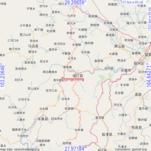
Zhongcheng GPS coordinates[2]
28° 35' 27.708" North, 103° 56' 22.488" East
| Map corner | latitude | longitude |
|---|---|---|
| Upper-left | 29.20659°, | 103.23646° |
| Center: | 28.59103°, | 103.93958° |
| Lower-right: | 27.97184°, | 104.64271° |
| Map W x H: | 137.3×137.3 km | = 85.3×85.3mi |
| max Lat: | 53.31946° ⇑68.9% North |
| Zhongcheng: | 28.59103° |
| min Lat: | ⇓31.1% South 18.22056° |
| min Long | Zhongcheng | max Long |
| 75.07348° | 103.93958° | 134.28917° |
| W 9.6%⇐ | ⇒90.4% E |
Elevation
Elevation of Zhongcheng is 475 m = 1558 ft, and this is 9.8 m = 32 ft below average elevation for this country.
| Max E: |
5622 m = 18445 ft | 27% |
| Avg. | 484.8 m = 1591 ft | |
| Zhongcheng | 475 m = 1558 ft | |
Min E: |
-3 m = -10 ft | 73% |
See also: China elevation on elevation.city.
Geographical zone
Zhongcheng is located in North temperate zone (between Tropic of Cancer and the Arctic Circle). Distance of this Northern Tropic circle is 573.1 km =356.1 mi to South.| Distance of | km | miles | from Zhongcheng |
|---|---|---|---|
| North Pole | 6828 | 4242.7 | to North |
| Arctic Circle | 4222.1 | 2623.5 | to North |
| Tropic Cancer | 573.1 | 356.1 | to South |
| Equator | 3179 | 1975.3 | to South |


Nearby cities:
15 places around Zhongcheng: (largest is in red/bold)
• Changping
43.4 km =27 mi,  190°
190°
• Chuansiba
35.4 km =22 mi,  148°
148°
• Huiyi
27.2 km =16.9 mi,  83°
83°
• Minjian
47.7 km =29.6 mi,  306°
306°
• Mugan
47.3 km =29.4 mi,  176°
176°
• Muxi
41.2 km =25.6 mi,  354°
354°
• Nahaping
19.4 km =12.1 mi,  204°
204°
• Pu’er
43.9 km =27.3 mi, 149°
• Taipingdian
27.8 km =17.3 mi,  97°
97°
• Tantou
46.8 km =29.1 mi,  136°
136°
• Tantouchang
46 km =28.6 mi,  132°
132°
• Xiangjiaba
45.6 km =28.3 mi, 84°
• Xiluodu
48.5 km =30.1 mi,  217°
217°
• Xinfa
45.7 km =28.4 mi,  54°
54°
• Xishaqiao
32.4 km =20.1 mi,  172°
172°
Sources, notices
• [Note1] Compared only with cities in China existing in our database
• [Src1] Map data: © OpenStreetMap contributors (CC-BY-SA)
• [Src2] Other city data from geonames.org with taken over terms of usage.
• [Src3] Geographical zone / Annual Mean Temperature by Robert A. Rohde @ Wikipedia
