Liancheng geodata
Liancheng (Zhejiang) is a seat of a fourth-order administrative division; located in China in Asia/Shanghai (GMT+8) time zone. In our database, there are 1268 cities with bigger population. Compared to other cities in China, 69.9% of cities are located further ↑North; 80.9% of cities are located further ←West and 68.7% of cities have higher elevation than Liancheng. Note1


Liancheng GPS coordinates[2]
28° 28' 27.588" North, 119° 51' 11.952" East
| Map corner | latitude | longitude |
|---|---|---|
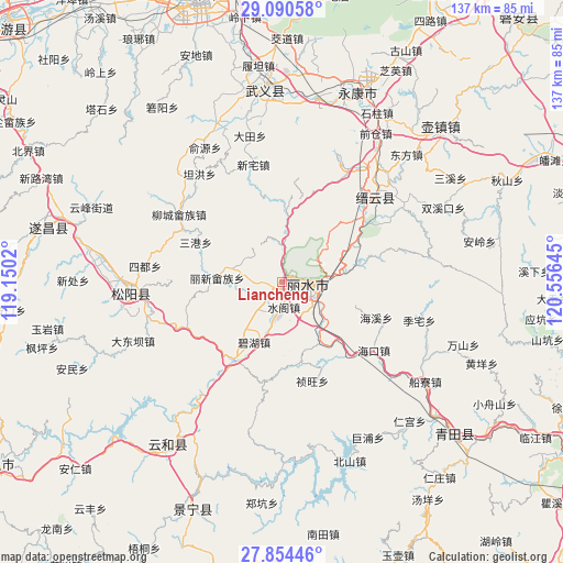
| Upper-left | 29.09058°, | 119.1502° |
| Center: | 28.47433°, | 119.85332° |
| Lower-right: | 27.85446°, | 120.55645° |
| Map W x H: | 137.4×137.4 km | = 85.4×85.4mi |
| max Lat: | 53.31946° ⇑69.9% North |
| Liancheng: | 28.47433° |
| min Lat: | ⇓30.1% South 18.22056° |
| min Long | Liancheng | max Long |
| 75.07348° | 119.85332° | 134.28917° |
| W 80.9%⇐ | ⇒19.1% E |
Elevation
Elevation of Liancheng is 57 m = 187 ft, and this is 427.8 m = 1404 ft below average elevation for this country.
| Max E: |
5622 m = 18445 ft | 68.7% |
| Avg. | 484.8 m = 1591 ft | |
| Liancheng | 57 m = 187 ft | |
Min E: |
-3 m = -10 ft | 31.3% |
See also: China elevation on elevation.city.
Geographical zone
Liancheng is located in North temperate zone (between Tropic of Cancer and the Arctic Circle). Distance of this Northern Tropic circle is 560.1 km =348 mi to South.| Distance of | km | miles | from Liancheng |
|---|---|---|---|
| North Pole | 6841 | 4250.8 | to North |
| Arctic Circle | 4235.1 | 2631.6 | to North |
| Tropic Cancer | 560.1 | 348 | to South |
| Equator | 3166 | 1967.3 | to South |


Nearby cities:
15 places around Liancheng: (largest is in red/bold)
• Bihu
16.2 km =10.1 mi,  203°
203°
• Dongdu
25.5 km =15.8 mi,  50°
50°
• Fangxi
29 km =18 mi,  74°
74°
• Haikou
27.9 km =17.3 mi,  126°
126°
• Haixi
24.4 km =15.2 mi,  110°
110°
• Huangcun
19.5 km =12.1 mi,  78°
78°
• Lakou
18.1 km =11.2 mi,  146°
146°
• Lishui
5.8 km =3.6 mi, 105°
• Qili
30.4 km =18.9 mi,  41°
41°
• Shijian
28.7 km =17.8 mi,  88°
88°
• Shuangxi
13.4 km =8.3 mi,  8°
8°
• Shuige
6.4 km =4 mi,  174°
174°
• Shuqiao
21.2 km =13.2 mi,  104°
104°
• Wuyun
28.9 km =18 mi, 46°
• Xinjian
32.2 km =20 mi,  30°
30°
Sources, notices
• [Note1] Compared only with cities in China existing in our database
• [Src1] Map data: © OpenStreetMap contributors (CC-BY-SA)
• [Src2] Other city data from geonames.org with taken over terms of usage.
• [Src3] Geographical zone / Annual Mean Temperature by Robert A. Rohde @ Wikipedia
