Minggang geodata
Minggang (Zhejiang) is a seat of a fourth-order administrative division; located in China in Asia/Shanghai (GMT+8) time zone. In our database, there are 1268 cities with bigger population. Compared to other cities in China, 63.3% of cities are located further ↑North; 90.5% of cities are located further ←West and 55.1% of cities have higher elevation than Minggang. Note1


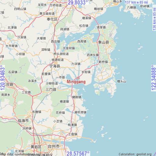
Minggang GPS coordinates[2]
29° 11' 28.752" North, 121° 38' 15.9" East
| Map corner | latitude | longitude |
|---|---|---|
| Upper-left | 29.8033°, | 120.93463° |
| Center: | 29.19132°, | 121.63775° |
| Lower-right: | 28.57567°, | 122.34088° |
| Map W x H: | 136.5×136.5 km | = 84.8×84.8mi |
| max Lat: | 53.31946° ⇑63.3% North |
| Minggang: | 29.19132° |
| min Lat: | ⇓36.7% South 18.22056° |
| min Long | Minggang | max Long |
| 75.07348° | 121.63775° | 134.28917° |
| W 90.5%⇐ | ⇒9.5% E |
Elevation
Elevation of Minggang is 131 m = 430 ft, and this is 353.8 m = 1161 ft below average elevation for this country.
| Max E: |
5622 m = 18445 ft | 55.1% |
| Avg. | 484.8 m = 1591 ft | |
| Minggang | 131 m = 430 ft | |
Min E: |
-3 m = -10 ft | 44.9% |
See also: China elevation on elevation.city.
Geographical zone
Minggang is located in North temperate zone (between Tropic of Cancer and the Arctic Circle). Distance of this Northern Tropic circle is 639.9 km =397.6 mi to South.| Distance of | km | miles | from Minggang |
|---|---|---|---|
| North Pole | 6761.3 | 4201.3 | to North |
| Arctic Circle | 4155.4 | 2582 | to North |
| Tropic Cancer | 639.9 | 397.6 | to South |
| Equator | 3245.8 | 2016.8 | to South |


Nearby cities:
15 places around Minggang: (largest is in red/bold)
• Changjie
9.2 km =5.7 mi,  45°
45°
• Chengguan
22.7 km =14.1 mi,  298°
298°
• Dajiahe
27.7 km =17.2 mi,  342°
342°
• Dingtang
20.3 km =12.6 mi,  77°
77°
• Haiyou
26.7 km =16.6 mi,  253°
253°
• Hepu
26.1 km =16.2 mi,  99°
99°
• Jiantiao
16.4 km =10.2 mi,  183°
183°
• Liu’ao
12.7 km =7.9 mi,  201°
201°
• Liyang
13 km =8.1 mi,  350°
350°
• Ninghai
23.4 km =14.5 mi, 297°
• Qiantong
27.9 km =17.3 mi,  277°
277°
• Shaliu
23.5 km =14.6 mi,  258°
258°
• Sizhoutou
23.8 km =14.8 mi,  31°
31°
• Xinqiao
25.9 km =16.1 mi,  57°
57°
• Yishi
15.9 km =9.9 mi,  273°
273°
Sources, notices
• [Note1] Compared only with cities in China existing in our database
• [Src1] Map data: © OpenStreetMap contributors (CC-BY-SA)
• [Src2] Other city data from geonames.org with taken over terms of usage.
• [Src3] Geographical zone / Annual Mean Temperature by Robert A. Rohde @ Wikipedia
