Yongjiang geodata
Yongjiang (Zhejiang) is a seat of a fourth-order administrative division; located in China in Asia/Shanghai (GMT+8) time zone. In our database, there are 1268 cities with bigger population. Compared to other cities in China, 55% of cities are located further ↑North; 90.2% of cities are located further ←West and 98.3% of cities have higher elevation than Yongjiang. Note1


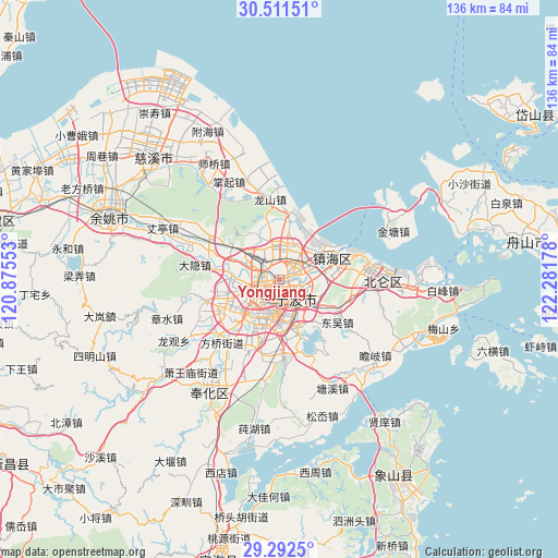
Yongjiang GPS coordinates[2]
29° 54' 13.932" North, 121° 34' 43.14" East
| Map corner | latitude | longitude |
|---|---|---|
| Upper-left | 30.51151°, | 120.87553° |
| Center: | 29.90387°, | 121.57865° |
| Lower-right: | 29.2925°, | 122.28178° |
| Map W x H: | 135.5×135.5 km | = 84.2×84.2mi |
| max Lat: | 53.31946° ⇑55% North |
| Yongjiang: | 29.90387° |
| min Lat: | ⇓45% South 18.22056° |
| min Long | Yongjiang | max Long |
| 75.07348° | 121.57865° | 134.28917° |
| W 90.2%⇐ | ⇒9.8% E |
Elevation
Elevation of Yongjiang is 4 m = 13 ft, and this is 480.8 m = 1577 ft below average elevation for this country.
| Max E: |
5622 m = 18445 ft | 98.3% |
| Avg. | 484.8 m = 1591 ft | |
| Yongjiang | 4 m = 13 ft | |
Min E: |
-3 m = -10 ft | 1.7% |
See also: China elevation on elevation.city.
Geographical zone
Yongjiang is located in North temperate zone (between Tropic of Cancer and the Arctic Circle). Distance of this Northern Tropic circle is 719.1 km =446.8 mi to South.| Distance of | km | miles | from Yongjiang |
|---|---|---|---|
| North Pole | 6682.1 | 4152.1 | to North |
| Arctic Circle | 4076.2 | 2532.8 | to North |
| Tropic Cancer | 719.1 | 446.8 | to South |
| Equator | 3325 | 2066.1 | to South |


Nearby cities:
15 places around Yongjiang: (largest is in red/bold)
• Dongjiao
3.3 km =2.1 mi,  166°
166°
• Duantang
7.9 km =4.9 mi,  221°
221°
• Fuming
4.1 km =2.5 mi,  146°
146°
• Gaoqiao
12 km =7.5 mi,  272°
272°
• Hongtang
8.8 km =5.5 mi,  307°
307°
• Luotuo
9 km =5.6 mi,  7°
7°
• Ningbo
4 km =2.5 mi, 224°
• Qiu’ai
7.7 km =4.8 mi,  138°
138°
• Shiqi
11.5 km =7.1 mi, 218°
• Wuxiang
12.3 km =7.6 mi,  121°
121°
• Xiaying
11.1 km =6.9 mi, 173°
• Zhaobaoshan
12.8 km =8 mi,  55°
55°
• Zhonggongmiao
9.5 km =5.9 mi,  204°
204°
• Zhuangqiao
4.1 km =2.5 mi, 314°
• Zhuangshi
4.4 km =2.7 mi,  42°
42°
Sources, notices
• [Note1] Compared only with cities in China existing in our database
• [Src1] Map data: © OpenStreetMap contributors (CC-BY-SA)
• [Src2] Other city data from geonames.org with taken over terms of usage.
• [Src3] Geographical zone / Annual Mean Temperature by Robert A. Rohde @ Wikipedia
