Zhuolu geodata
Zhuolu (Gansu) is a seat of a fourth-order administrative division; located in China in Asia/Shanghai (GMT+8) time zone. In our database, there are 1268 cities with bigger population. Compared to other cities in China, 73.9% of cities are located further ↓South; 91.1% of cities are located further →East and 96.6% of cities have lower elevation than Zhuolu. Note1


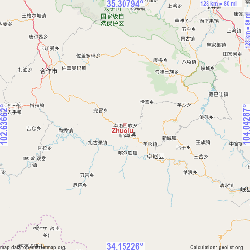
Zhuolu GPS coordinates[2]
34° 43' 55.632" North, 103° 20' 23.064" East
| Map corner | latitude | longitude |
|---|---|---|
| Upper-left | 35.30794°, | 102.63662° |
| Center: | 34.73212°, | 103.33974° |
| Lower-right: | 34.15226°, | 104.04287° |
| Map W x H: | 128.5×128.5 km | = 79.8×79.8mi |
| max Lat: | 53.31946° ⇑26.1% North |
| Zhuolu: | 34.73212° |
| min Lat: | ⇓73.9% South 18.22056° |
| min Long | Zhuolu | max Long |
| 75.07348° | 103.33974° | 134.28917° |
| W 8.9%⇐ | ⇒91.1% E |
Elevation
Elevation of Zhuolu is 2879 m = 9446 ft, and this is 2394.2 m = 7855 ft above average elevation for this country.
| Max E: |
5622 m = 18445 ft | 3.4% |
| Zhuolu | 2879 m 9446 ft | |
| Avg. | 484.8 m = 1591 ft | |
Min E: |
-3 m = -10 ft | 96.6% |
See also: China elevation on elevation.city.
Geographical zone
Zhuolu is located in North temperate zone (between Tropic of Cancer and the Arctic Circle). Distance of this Northern Tropic circle is 1255.9 km =780.4 mi to South.| Distance of | km | miles | from Zhuolu |
|---|---|---|---|
| North Pole | 6145.2 | 3818.4 | to North |
| Arctic Circle | 3539.3 | 2199.2 | to North |
| Tropic Cancer | 1255.9 | 780.4 | to South |
| Equator | 3861.8 | 2399.6 | to South |


Nearby cities:
15 places around Zhuolu: (largest is in red/bold)
• Biandu
28.7 km =17.8 mi,  106°
106°
• Changchuan
8.4 km =5.2 mi,  102°
102°
• Chubu
13.4 km =8.3 mi,  199°
199°
• Dazu
18.2 km =11.3 mi,  155°
155°
• Guzhan
5.7 km =3.5 mi,  223°
223°
• Jiamaogong
22 km =13.7 mi,  272°
272°
• Kache
14.5 km =9 mi,  176°
176°
• Lintan Chengguanzhen
4.9 km =3 mi,  166°
166°
• Liulin
21.8 km =13.5 mi,  136°
136°
• Liushun
20.6 km =12.8 mi,  116°
116°
• Qiagai
16.6 km =10.3 mi,  40°
40°
• Shencang
3.7 km =2.3 mi,  85°
85°
• Wanmao
14.8 km =9.2 mi,  300°
300°
• Xincheng
23.5 km =14.6 mi, 105°
• Yangyong
15.4 km =9.6 mi,  128°
128°
Sources, notices
• [Note1] Compared only with cities in China existing in our database
• [Src1] Map data: © OpenStreetMap contributors (CC-BY-SA)
• [Src2] Other city data from geonames.org with taken over terms of usage.
• [Src3] Geographical zone / Annual Mean Temperature by Robert A. Rohde @ Wikipedia
