Erdaohe geodata
Erdaohe (Shaanxi) is a seat of a fourth-order administrative division; located in China in Asia/Shanghai (GMT+8) time zone. In our database, there are 1268 cities with bigger population. Compared to other cities in China, 67.2% of cities are located further ↓South; 84.2% of cities are located further →East and 87% of cities have lower elevation than Erdaohe. Note1


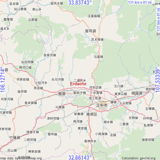
Erdaohe GPS coordinates[2]
33° 15' 5.076" North, 106° 49' 48.936" East
| Map corner | latitude | longitude |
|---|---|---|
| Upper-left | 33.83743°, | 106.12714° |
| Center: | 33.25141°, | 106.83026° |
| Lower-right: | 32.66143°, | 107.53339° |
| Map W x H: | 130.8×130.8 km | = 81.3×81.3mi |
| max Lat: | 53.31946° ⇑32.8% North |
| Erdaohe: | 33.25141° |
| min Lat: | ⇓67.2% South 18.22056° |
| min Long | Erdaohe | max Long |
| 75.07348° | 106.83026° | 134.28917° |
| W 15.8%⇐ | ⇒84.2% E |
Elevation
Elevation of Erdaohe is 1110 m = 3642 ft, and this is 625.2 m = 2051 ft above average elevation for this country.
| Max E: |
5622 m = 18445 ft | 13% |
| Erdaohe | 1110 m 3642 ft | |
| Avg. | 484.8 m = 1591 ft | |
Min E: |
-3 m = -10 ft | 87% |
See also: China elevation on elevation.city.
Geographical zone
Erdaohe is located in North temperate zone (between Tropic of Cancer and the Arctic Circle). Distance of this Northern Tropic circle is 1091.3 km =678.1 mi to South.| Distance of | km | miles | from Erdaohe |
|---|---|---|---|
| North Pole | 6309.9 | 3920.8 | to North |
| Arctic Circle | 3704 | 2301.6 | to North |
| Tropic Cancer | 1091.3 | 678.1 | to South |
| Equator | 3697.2 | 2297.3 | to South |


Nearby cities:
15 places around Erdaohe: (largest is in red/bold)
• Changgouhe
18.6 km =11.6 mi,  271°
271°
• Changlin
13.9 km =8.6 mi,  149°
149°
• Dingjunshan
20.2 km =12.6 mi,  231°
231°
• Huangsha
13.8 km =8.6 mi,  197°
197°
• Jinquan
11.8 km =7.3 mi,  173°
173°
• Laodaosi
10.5 km =6.5 mi, 151°
• Longjiang
18.7 km =11.6 mi,  139°
139°
• Mianyang
16.4 km =10.2 mi, 230°
• Qingqiaoyi
16.1 km =10 mi,  57°
57°
• Tonggousi
11.7 km =7.3 mi,  220°
220°
• Wenquan
15.4 km =9.6 mi,  211°
211°
• Xinjiezi
10.1 km =6.3 mi,  182°
182°
• Xinyuan
19.8 km =12.3 mi, 135°
• Zhoujiashan
13 km =8.1 mi, 226°
• Zongying
17.4 km =10.8 mi,  126°
126°
Sources, notices
• [Note1] Compared only with cities in China existing in our database
• [Src1] Map data: © OpenStreetMap contributors (CC-BY-SA)
• [Src2] Other city data from geonames.org with taken over terms of usage.
• [Src3] Geographical zone / Annual Mean Temperature by Robert A. Rohde @ Wikipedia
