Zongying geodata
Zongying (Shaanxi) is a seat of a fourth-order administrative division; located in China in Asia/Shanghai (GMT+8) time zone. In our database, there are 1268 cities with bigger population. Compared to other cities in China, 66.9% of cities are located further ↓South; 83.7% of cities are located further →East and 75.7% of cities have lower elevation than Zongying. Note1


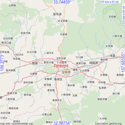
Zongying GPS coordinates[2]
33° 9' 28.584" North, 106° 58' 49.512" East
| Map corner | latitude | longitude |
|---|---|---|
| Upper-left | 33.74459°, | 106.2773° |
| Center: | 33.15794°, | 106.98042° |
| Lower-right: | 32.56734°, | 107.68355° |
| Map W x H: | 130.9×130.9 km | = 81.3×81.3mi |
| max Lat: | 53.31946° ⇑33.1% North |
| Zongying: | 33.15794° |
| min Lat: | ⇓66.9% South 18.22056° |
| min Long | Zongying | max Long |
| 75.07348° | 106.98042° | 134.28917° |
| W 16.3%⇐ | ⇒83.7% E |
Elevation
Elevation of Zongying is 537 m = 1762 ft, and this is 52.2 m = 171 ft above average elevation for this country.
| Max E: |
5622 m = 18445 ft | 24.3% |
| Zongying | 537 m 1762 ft | |
| Avg. | 484.8 m = 1591 ft | |
Min E: |
-3 m = -10 ft | 75.7% |
See also: China elevation on elevation.city.
Geographical zone
Zongying is located in North temperate zone (between Tropic of Cancer and the Arctic Circle). Distance of this Northern Tropic circle is 1080.9 km =671.6 mi to South.| Distance of | km | miles | from Zongying |
|---|---|---|---|
| North Pole | 6320.2 | 3927.2 | to North |
| Arctic Circle | 3714.4 | 2308 | to North |
| Tropic Cancer | 1080.9 | 671.6 | to South |
| Equator | 3686.8 | 2290.9 | to South |


Nearby cities:
15 places around Zongying: (largest is in red/bold)
• Changlin
7.2 km =4.5 mi,  256°
256°
• Dahekan
14 km =8.7 mi,  158°
158°
• Guotan
13.9 km =8.6 mi,  197°
197°
• Hanzhong
10 km =6.2 mi, 157°
• Hujiaying
15.4 km =9.6 mi, 164°
• Jinquan
12.7 km =7.9 mi, 264°
• Laodaosi
9 km =5.6 mi,  277°
277°
• Laojun
7.1 km =4.4 mi,  124°
124°
• Liangshan
8.7 km =5.4 mi, 203°
• Longjiang
4.4 km =2.7 mi,  206°
206°
• Qili
11.2 km =7 mi,  141°
141°
• Wuxiang
7.1 km =4.4 mi,  63°
63°
• Xinjiezi
14.5 km =9 mi,  271°
271°
• Xinyuan
3.6 km =2.2 mi,  179°
179°
• Yangchun
15.7 km =9.8 mi, 207°
Sources, notices
• [Note1] Compared only with cities in China existing in our database
• [Src1] Map data: © OpenStreetMap contributors (CC-BY-SA)
• [Src2] Other city data from geonames.org with taken over terms of usage.
• [Src3] Geographical zone / Annual Mean Temperature by Robert A. Rohde @ Wikipedia
