Tiehe geodata
Tiehe (Jiangxi) is a seat of a fourth-order administrative division; located in China in Asia/Shanghai (GMT+8) time zone. In our database, there are 1268 cities with bigger population. Compared to other cities in China, 65.1% of cities are located further ↑North; 59.9% of cities are located further ←West and 80.8% of cities have higher elevation than Tiehe. Note1


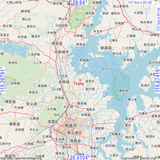
Tiehe GPS coordinates[2]
29° 1' 37.308" North, 115° 58' 15.708" East
| Map corner | latitude | longitude |
|---|---|---|
| Upper-left | 29.64°, | 115.26791° |
| Center: | 29.02703°, | 115.97103° |
| Lower-right: | 28.4104°, | 116.67416° |
| Map W x H: | 136.7×136.7 km | = 84.9×84.9mi |
| max Lat: | 53.31946° ⇑65.1% North |
| Tiehe: | 29.02703° |
| min Lat: | ⇓34.9% South 18.22056° |
| min Long | Tiehe | max Long |
| 75.07348° | 115.97103° | 134.28917° |
| W 59.9%⇐ | ⇒40.1% E |
Elevation
Elevation of Tiehe is 25 m = 82 ft, and this is 459.8 m = 1509 ft below average elevation for this country.
| Max E: |
5622 m = 18445 ft | 80.8% |
| Avg. | 484.8 m = 1591 ft | |
| Tiehe | 25 m = 82 ft | |
Min E: |
-3 m = -10 ft | 19.2% |
See also: China elevation on elevation.city.
Geographical zone
Tiehe is located in North temperate zone (between Tropic of Cancer and the Arctic Circle). Distance of this Northern Tropic circle is 621.6 km =386.2 mi to South.| Distance of | km | miles | from Tiehe |
|---|---|---|---|
| North Pole | 6779.6 | 4212.6 | to North |
| Arctic Circle | 4173.7 | 2593.4 | to North |
| Tropic Cancer | 621.6 | 386.2 | to South |
| Equator | 3227.5 | 2005.5 | to South |


Nearby cities:
15 places around Tiehe: (largest is in red/bold)
• Aicheng
21.5 km =13.4 mi,  288°
288°
• Changyi
8.7 km =5.4 mi,  91°
91°
• Datangping
7.6 km =4.7 mi,  241°
241°
• Jinqiao
8.8 km =5.5 mi,  223°
223°
• Jiuhe
15.2 km =9.4 mi,  282°
282°
• Lixin
22.4 km =13.9 mi,  268°
268°
• Luoting
23.5 km =14.6 mi,  229°
229°
• Makou
21.8 km =13.5 mi,  249°
249°
• Qiaoshe
19.7 km =12.2 mi,  176°
176°
• Sanjiao
12.6 km =7.8 mi, 281°
• Tubu
15.5 km =9.6 mi, 277°
• Wucheng
17.8 km =11.1 mi,  10°
10°
• Xiangshan
8.2 km =5.1 mi,  173°
173°
• Xixia
22.5 km =14 mi,  213°
213°
• Yangsi
21.3 km =13.2 mi,  259°
259°
Sources, notices
• [Note1] Compared only with cities in China existing in our database
• [Src1] Map data: © OpenStreetMap contributors (CC-BY-SA)
• [Src2] Other city data from geonames.org with taken over terms of usage.
• [Src3] Geographical zone / Annual Mean Temperature by Robert A. Rohde @ Wikipedia
