Xixia geodata
Xixia (Jiangxi) is a seat of a fourth-order administrative division; located in China in Asia/Shanghai (GMT+8) time zone. In our database, there are 1268 cities with bigger population. Compared to other cities in China, 66.7% of cities are located further ↑North; 59.2% of cities are located further ←West and 79.3% of cities have higher elevation than Xixia. Note1


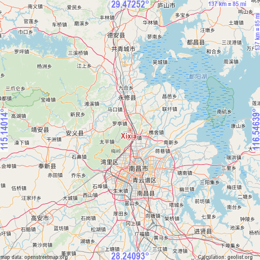
Xixia GPS coordinates[2]
28° 51' 30.78" North, 115° 50' 35.736" East
| Map corner | latitude | longitude |
|---|---|---|
| Upper-left | 29.47252°, | 115.14014° |
| Center: | 28.85855°, | 115.84326° |
| Lower-right: | 28.24093°, | 116.54639° |
| Map W x H: | 136.9×136.9 km | = 85.1×85.1mi |
| max Lat: | 53.31946° ⇑66.7% North |
| Xixia: | 28.85855° |
| min Lat: | ⇓33.3% South 18.22056° |
| min Long | Xixia | max Long |
| 75.07348° | 115.84326° | 134.28917° |
| W 59.2%⇐ | ⇒40.8% E |
Elevation
Elevation of Xixia is 28 m = 92 ft, and this is 456.8 m = 1499 ft below average elevation for this country.
| Max E: |
5622 m = 18445 ft | 79.3% |
| Avg. | 484.8 m = 1591 ft | |
| Xixia | 28 m = 92 ft | |
Min E: |
-3 m = -10 ft | 20.7% |
See also: China elevation on elevation.city.
Geographical zone
Xixia is located in North temperate zone (between Tropic of Cancer and the Arctic Circle). Distance of this Northern Tropic circle is 602.9 km =374.6 mi to South.| Distance of | km | miles | from Xixia |
|---|---|---|---|
| North Pole | 6798.3 | 4224.3 | to North |
| Arctic Circle | 4192.4 | 2605 | to North |
| Tropic Cancer | 602.9 | 374.6 | to South |
| Equator | 3208.8 | 1993.9 | to South |


Nearby cities:
15 places around Xixia: (largest is in red/bold)
• Changjun
12.6 km =7.8 mi,  273°
273°
• Changleng
17.8 km =11.1 mi,  188°
188°
• Chengfeng
15.8 km =9.8 mi,  304°
304°
• Datangping
16.1 km =10 mi,  20°
20°
• Jiaoqiao
12.7 km =7.9 mi,  173°
173°
• Jinqiao
13.9 km =8.6 mi,  27°
27°
• Lehua
4.7 km =2.9 mi,  153°
153°
• Luoting
6.5 km =4 mi, 302°
• Makou
13.5 km =8.4 mi,  323°
323°
• Meiling
12.1 km =7.5 mi,  232°
232°
• Qiaoshe
13.7 km =8.5 mi,  93°
93°
• Taiping
14 km =8.7 mi,  244°
244°
• Xiangshan
17.1 km =10.6 mi,  51°
51°
• Yangsi
17.3 km =10.7 mi,  330°
330°
• Yangzizhou
16.3 km =10.1 mi,  158°
158°
Sources, notices
• [Note1] Compared only with cities in China existing in our database
• [Src1] Map data: © OpenStreetMap contributors (CC-BY-SA)
• [Src2] Other city data from geonames.org with taken over terms of usage.
• [Src3] Geographical zone / Annual Mean Temperature by Robert A. Rohde @ Wikipedia
