Changsha geodata
Changsha (Jiangxi) is a seat of a fourth-order administrative division; located in China in Asia/Shanghai (GMT+8) time zone. In our database, there are 1268 cities with bigger population. Compared to other cities in China, 84.4% of cities are located further ↑North; 57.1% of cities are located further ←West and 53.4% of cities have lower elevation than Changsha. Note1


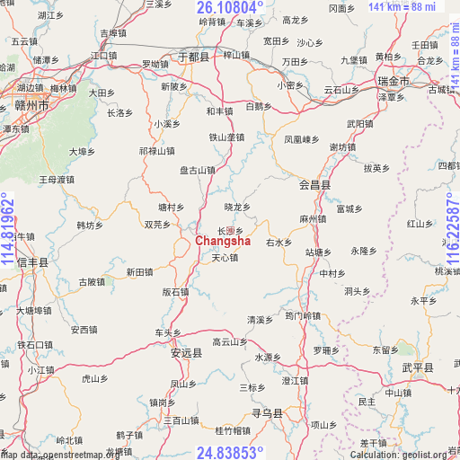
Changsha GPS coordinates[2]
25° 28' 29.856" North, 115° 31' 21.864" East
| Map corner | latitude | longitude |
|---|---|---|
| Upper-left | 26.10804°, | 114.81962° |
| Center: | 25.47496°, | 115.52274° |
| Lower-right: | 24.83853°, | 116.22587° |
| Map W x H: | 141.2×141.2 km | = 87.7×87.7mi |
| max Lat: | 53.31946° ⇑84.4% North |
| Changsha: | 25.47496° |
| min Lat: | ⇓15.6% South 18.22056° |
| min Long | Changsha | max Long |
| 75.07348° | 115.52274° | 134.28917° |
| W 57.1%⇐ | ⇒42.9% E |
Elevation
Elevation of Changsha is 192 m = 630 ft, and this is 292.8 m = 961 ft below average elevation for this country.
| Max E: |
5622 m = 18445 ft | 46.6% |
| Avg. | 484.8 m = 1591 ft | |
| Changsha | 192 m = 630 ft | |
Min E: |
-3 m = -10 ft | 53.4% |
See also: China elevation on elevation.city.
Geographical zone
Changsha is located in North temperate zone (between Tropic of Cancer and the Arctic Circle). Distance of this Northern Tropic circle is 226.6 km =140.8 mi to South.| Distance of | km | miles | from Changsha |
|---|---|---|---|
| North Pole | 7174.5 | 4458 | to North |
| Arctic Circle | 4568.6 | 2838.8 | to North |
| Tropic Cancer | 226.6 | 140.8 | to South |
| Equator | 2832.6 | 1760.1 | to South |


Nearby cities:
15 places around Changsha: (largest is in red/bold)
• Banshi
25.2 km =15.7 mi,  221°
221°
• Caifang
20.9 km =13 mi,  201°
201°
• Fucha
11.7 km =7.3 mi,  308°
308°
• Gaopai
8.7 km =5.4 mi,  79°
79°
• Jingshi
21.7 km =13.5 mi,  353°
353°
• Longbu
14.7 km =9.1 mi,  269°
269°
• Mazhou
25.6 km =15.9 mi, 81°
• Pangushan
21.2 km =13.2 mi,  331°
331°
• Shuangyuan
22.4 km =13.9 mi,  275°
275°
• Tangcun
19.5 km =12.1 mi,  291°
291°
• Tianxin
8.7 km =5.4 mi,  192°
192°
• Xiaolong
7.7 km =4.8 mi,  16°
16°
• Youshui
15.2 km =9.4 mi,  103°
103°
• Zhongshi
14.4 km =8.9 mi,  227°
227°
• Zhulan
25.3 km =15.7 mi,  48°
48°
Sources, notices
• [Note1] Compared only with cities in China existing in our database
• [Src1] Map data: © OpenStreetMap contributors (CC-BY-SA)
• [Src2] Other city data from geonames.org with taken over terms of usage.
• [Src3] Geographical zone / Annual Mean Temperature by Robert A. Rohde @ Wikipedia
