Renhe geodata
Renhe (Jiangxi) is a seat of a fourth-order administrative division; located in China in Asia/Shanghai (GMT+8) time zone. In our database, there are 1268 cities with bigger population. Compared to other cities in China, 73.9% of cities are located further ↑North; 53.9% of cities are located further ←West and 62.1% of cities have higher elevation than Renhe. Note1


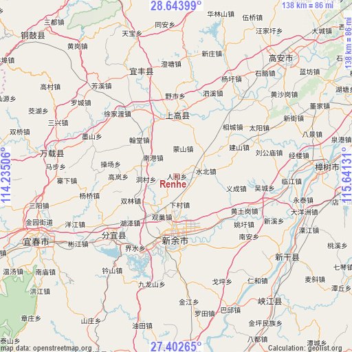
Renhe GPS coordinates[2]
28° 1' 30.396" North, 114° 56' 17.448" East
| Map corner | latitude | longitude |
|---|---|---|
| Upper-left | 28.64399°, | 114.23506° |
| Center: | 28.02511°, | 114.93818° |
| Lower-right: | 27.40265°, | 115.64131° |
| Map W x H: | 138×138 km | = 85.7×85.7mi |
| max Lat: | 53.31946° ⇑73.9% North |
| Renhe: | 28.02511° |
| min Lat: | ⇓26.1% South 18.22056° |
| min Long | Renhe | max Long |
| 75.07348° | 114.93818° | 134.28917° |
| W 53.9%⇐ | ⇒46.1% E |
Elevation
Elevation of Renhe is 87 m = 285 ft, and this is 397.8 m = 1305 ft below average elevation for this country.
| Max E: |
5622 m = 18445 ft | 62.1% |
| Avg. | 484.8 m = 1591 ft | |
| Renhe | 87 m = 285 ft | |
Min E: |
-3 m = -10 ft | 37.9% |
See also: China elevation on elevation.city.
Geographical zone
Renhe is located in North temperate zone (between Tropic of Cancer and the Arctic Circle). Distance of this Northern Tropic circle is 510.2 km =317 mi to South.| Distance of | km | miles | from Renhe |
|---|---|---|---|
| North Pole | 6891 | 4281.9 | to North |
| Arctic Circle | 4285.1 | 2662.6 | to North |
| Tropic Cancer | 510.2 | 317 | to South |
| Equator | 3116.1 | 1936.3 | to South |


Nearby cities:
15 places around Renhe: (largest is in red/bold)
• Beigang
18.6 km =11.6 mi,  125°
125°
• Damiao
7.8 km =4.8 mi,  317°
317°
• Dongcun
12.2 km =7.6 mi,  264°
264°
• Guanchao
17.1 km =10.6 mi,  205°
205°
• Hantang
20.4 km =12.7 mi,  314°
314°
• Hushan
8 km =5 mi,  53°
53°
• Mahong
14.1 km =8.8 mi,  146°
146°
• Mengshan
11.2 km =7 mi,  12°
12°
• Nangang
11.9 km =7.4 mi, 307°
• Ouli
15 km =9.3 mi,  223°
223°
• Shangganshan
20.5 km =12.7 mi, 8°
• Shuanglin
20.3 km =12.6 mi,  242°
242°
• Shuibei
11.8 km =7.3 mi,  81°
81°
• Tiannan
18.9 km =11.7 mi,  61°
61°
• Xiacun
11.4 km =7.1 mi,  174°
174°
Sources, notices
• [Note1] Compared only with cities in China existing in our database
• [Src1] Map data: © OpenStreetMap contributors (CC-BY-SA)
• [Src2] Other city data from geonames.org with taken over terms of usage.
• [Src3] Geographical zone / Annual Mean Temperature by Robert A. Rohde @ Wikipedia
