Nangang geodata
Nangang (Jiangxi) is a seat of a fourth-order administrative division; located in China in Asia/Shanghai (GMT+8) time zone. In our database, there are 1268 cities with bigger population. Compared to other cities in China, 73.4% of cities are located further ↑North; 53.3% of cities are located further ←West and 63.3% of cities have higher elevation than Nangang. Note1


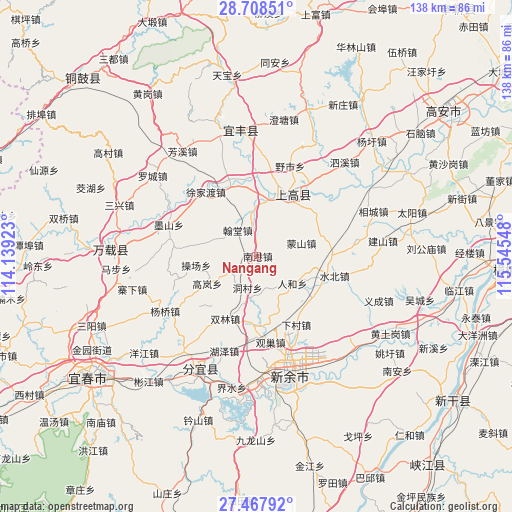
Nangang GPS coordinates[2]
28° 5' 24.036" North, 114° 50' 32.46" East
| Map corner | latitude | longitude |
|---|---|---|
| Upper-left | 28.70851°, | 114.13923° |
| Center: | 28.09001°, | 114.84235° |
| Lower-right: | 27.46792°, | 115.54548° |
| Map W x H: | 137.9×137.9 km | = 85.7×85.7mi |
| max Lat: | 53.31946° ⇑73.4% North |
| Nangang: | 28.09001° |
| min Lat: | ⇓26.6% South 18.22056° |
| min Long | Nangang | max Long |
| 75.07348° | 114.84235° | 134.28917° |
| W 53.3%⇐ | ⇒46.7% E |
Elevation
Elevation of Nangang is 81 m = 266 ft, and this is 403.8 m = 1325 ft below average elevation for this country.
| Max E: |
5622 m = 18445 ft | 63.3% |
| Avg. | 484.8 m = 1591 ft | |
| Nangang | 81 m = 266 ft | |
Min E: |
-3 m = -10 ft | 36.7% |
See also: China elevation on elevation.city.
Geographical zone
Nangang is located in North temperate zone (between Tropic of Cancer and the Arctic Circle). Distance of this Northern Tropic circle is 517.4 km =321.5 mi to South.| Distance of | km | miles | from Nangang |
|---|---|---|---|
| North Pole | 6883.7 | 4277.3 | to North |
| Arctic Circle | 4277.9 | 2658.2 | to North |
| Tropic Cancer | 517.4 | 321.5 | to South |
| Equator | 3123.3 | 1940.7 | to South |


Nearby cities:
15 places around Nangang: (largest is in red/bold)
• Aoyang
18.3 km =11.4 mi,  24°
24°
• Caochang
16.8 km =10.4 mi,  262°
262°
• Damiao
4.4 km =2.7 mi,  110°
110°
• Dongcun
8.8 km =5.5 mi,  197°
197°
• Gaolan
15.2 km =9.4 mi,  241°
241°
• Hantang
8.7 km =5.4 mi,  323°
323°
• Hushan
16.1 km =10 mi,  98°
98°
• Jinjiang
16.9 km =10.5 mi, 19°
• Luzhou
13 km =8.1 mi,  358°
358°
• Mengshan
12.4 km =7.7 mi,  72°
72°
• Ouli
18.2 km =11.3 mi,  182°
182°
• Renhe
11.9 km =7.4 mi,  127°
127°
• Shangganshan
18 km =11.2 mi,  43°
43°
• Shuanglin
18.7 km =11.6 mi,  207°
207°
• Taxia
18 km =11.2 mi, 36°
Sources, notices
• [Note1] Compared only with cities in China existing in our database
• [Src1] Map data: © OpenStreetMap contributors (CC-BY-SA)
• [Src2] Other city data from geonames.org with taken over terms of usage.
• [Src3] Geographical zone / Annual Mean Temperature by Robert A. Rohde @ Wikipedia
