Shaoyang geodata
Shaoyang (Jiangsu) is a seat of a third-order administrative division; located in China in Asia/Shanghai (GMT+8) time zone. In our database, there are 1268 cities with bigger population. Compared to other cities in China, 65.7% of cities are located further ↓South; 80.8% of cities are located further ←West and 95.9% of cities have higher elevation than Shaoyang. Note1


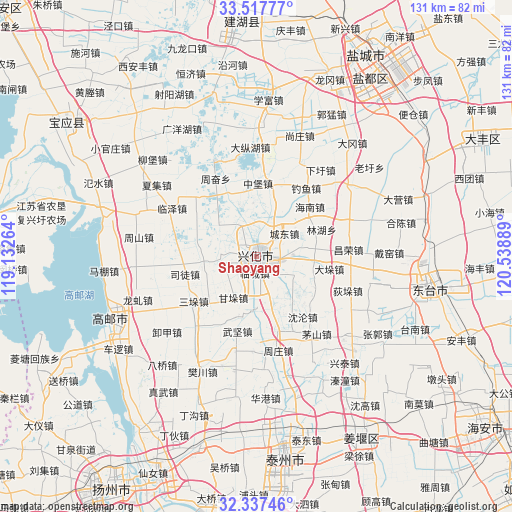
Shaoyang GPS coordinates[2]
32° 55' 46.488" North, 119° 50' 8.736" East
| Map corner | latitude | longitude |
|---|---|---|
| Upper-left | 33.51777°, | 119.13264° |
| Center: | 32.92958°, | 119.83576° |
| Lower-right: | 32.33746°, | 120.53889° |
| Map W x H: | 131.2×131.2 km | = 81.5×81.5mi |
| max Lat: | 53.31946° ⇑34.3% North |
| Shaoyang: | 32.92958° |
| min Lat: | ⇓65.7% South 18.22056° |
| min Long | Shaoyang | max Long |
| 75.07348° | 119.83576° | 134.28917° |
| W 80.8%⇐ | ⇒19.2% E |
Elevation
Elevation of Shaoyang is 6 m = 20 ft, and this is 478.8 m = 1571 ft below average elevation for this country.
| Max E: |
5622 m = 18445 ft | 95.9% |
| Avg. | 484.8 m = 1591 ft | |
| Shaoyang | 6 m = 20 ft | |
Min E: |
-3 m = -10 ft | 4.1% |
See also: China elevation on elevation.city.
Geographical zone
Shaoyang is located in North temperate zone (between Tropic of Cancer and the Arctic Circle). Distance of this Northern Tropic circle is 1055.5 km =655.9 mi to South.| Distance of | km | miles | from Shaoyang |
|---|---|---|---|
| North Pole | 6345.6 | 3943 | to North |
| Arctic Circle | 3739.7 | 2323.7 | to North |
| Tropic Cancer | 1055.5 | 655.9 | to South |
| Equator | 3661.4 | 2275.1 | to South |


Nearby cities:
15 places around Shaoyang: (largest is in red/bold)
• Chenbao
19.5 km =12.1 mi,  166°
166°
• Chengdong
9.4 km =5.8 mi,  50°
50°
• Daduo
18.9 km =11.7 mi,  101°
101°
• Duotian
2.1 km =1.3 mi, 96°
• Ganduo
9.2 km =5.7 mi,  229°
229°
• Gaojiazhuang
18.8 km =11.7 mi, 47°
• Hengjing
13.5 km =8.4 mi,  263°
263°
• Lincheng
4.6 km =2.9 mi,  183°
183°
• Shaoyang
2.7 km =1.7 mi,  254°
254°
• Shenlun
19.7 km =12.2 mi,  141°
141°
• Situ
19 km =11.8 mi, 256°
• Tangzhuang
20 km =12.4 mi,  207°
207°
• Xijiao
9.9 km =6.2 mi,  292°
292°
• Xinghua
1.1 km =0.7 mi,  352°
352°
• Zhuhong
15 km =9.3 mi,  110°
110°
Sources, notices
• [Note1] Compared only with cities in China existing in our database
• [Src1] Map data: © OpenStreetMap contributors (CC-BY-SA)
• [Src2] Other city data from geonames.org with taken over terms of usage.
• [Src3] Geographical zone / Annual Mean Temperature by Robert A. Rohde @ Wikipedia
