Nanwan geodata
Nanwan (Guangdong) is a seat of a fourth-order administrative division; located in China in Asia/Shanghai (GMT+8) time zone. In our database, there are 1268 cities with bigger population. Compared to other cities in China, 96% of cities are located further ↑North; 50.5% of cities are located further →East and 66.8% of cities have higher elevation than Nanwan. Note1


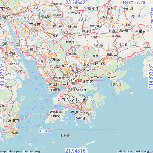
Nanwan GPS coordinates[2]
22° 35' 55.752" North, 114° 7' 49.44" East
| Map corner | latitude | longitude |
|---|---|---|
| Upper-left | 23.24642°, | 113.42728° |
| Center: | 22.59882°, | 114.1304° |
| Lower-right: | 21.94816°, | 114.83353° |
| Map W x H: | 144.4×144.4 km | = 89.7×89.7mi |
| max Lat: | 53.31946° ⇑96% North |
| Nanwan: | 22.59882° |
| min Lat: | ⇓4% South 18.22056° |
| min Long | Nanwan | max Long |
| 75.07348° | 114.1304° | 134.28917° |
| W 49.5%⇐ | ⇒50.5% E |
Elevation
Elevation of Nanwan is 65 m = 213 ft, and this is 419.8 m = 1377 ft below average elevation for this country.
| Max E: |
5622 m = 18445 ft | 66.8% |
| Avg. | 484.8 m = 1591 ft | |
| Nanwan | 65 m = 213 ft | |
Min E: |
-3 m = -10 ft | 33.2% |
See also: China elevation on elevation.city.
Geographical zone
Nanwan is located in North Torrid zone (between Equator and Tropic of Cancer). Distance of this Northern Tropic circle is 93.2 km =57.9 mi to North.| Distance of | km | miles | from Nanwan |
|---|---|---|---|
| North Pole | 7494.3 | 4656.7 | to North |
| Arctic Circle | 4888.4 | 3037.5 | to North |
| Tropic Cancer | 93.2 | 57.9 | to North |
| Equator | 2512.8 | 1561.4 | to South |


Nearby cities:
15 places around Nanwan: (largest is in red/bold)
• Bantian
9.3 km =5.8 mi,  296°
296°
• Buji
3.1 km =1.9 mi,  278°
278°
• Dalang
15.3 km =9.5 mi, 304°
• Guanlan
15.8 km =9.8 mi,  329°
329°
• Haishan
9.5 km =5.9 mi,  118°
118°
• Henggang
8.7 km =5.4 mi,  50°
50°
• Liantang
5.3 km =3.3 mi,  132°
132°
• Longcheng
14.4 km =8.9 mi,  37°
37°
• Longhua
14.1 km =8.8 mi, 297°
• Minzhi
9.9 km =6.2 mi,  286°
286°
• Pinghu
10.3 km =6.4 mi,  352°
352°
• Shahe
16.4 km =10.2 mi,  251°
251°
• Shatoujiao
11 km =6.8 mi, 116°
• Shenzhen
8.7 km =5.4 mi,  227°
227°
• Yantian
11.6 km =7.2 mi,  111°
111°
Sources, notices
• [Note1] Compared only with cities in China existing in our database
• [Src1] Map data: © OpenStreetMap contributors (CC-BY-SA)
• [Src2] Other city data from geonames.org with taken over terms of usage.
• [Src3] Geographical zone / Annual Mean Temperature by Robert A. Rohde @ Wikipedia
